You are here: Home > Network List > IU - Global Seismograph Network (GSN - IRIS/USGS) Stations List
> Station CTAO Charters Towers, Australia > Earthquake Result Viewer
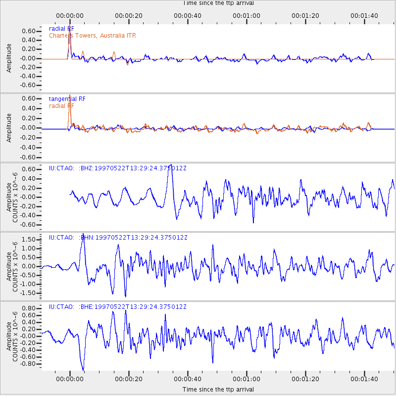
CTAO Charters Towers, Australia - Earthquake Result Viewer
*The percent match for this event was below the threshold and hence no stack was calculated.
| Earthquake location: |
Luzon, Philippines |
| Earthquake latitude/longitude: |
18.9/121.3 |
| Earthquake time(UTC): |
1997/05/22 (142) 13:21:36 GMT |
| Earthquake Depth: |
34 km |
| Earthquake Magnitude: |
5.7 MB, 5.6 MS, 6.1 UNKNOWN, 6.0 MW |
| Earthquake Catalog/Contributor: |
WHDF/NEIC |
|
| Network: |
IU Global Seismograph Network (GSN - IRIS/USGS) |
| Station: |
CTAO Charters Towers, Australia |
| Lat/Lon: |
20.09 S/146.25 E |
| Elevation: |
357 m |
|
| Distance: |
45.8 deg |
| Az: |
146.482 deg |
| Baz: |
326.208 deg |
| Ray Param: |
$rayparam |
*The percent match for this event was below the threshold and hence was not used in the summary stack. |
|
| Radial Match: |
72.44136 % |
| Radial Bump: |
400 |
| Transverse Match: |
54.13545 % |
| Transverse Bump: |
400 |
| SOD ConfigId: |
4480 |
| Insert Time: |
2010-03-03 14:35:51.454 +0000 |
| GWidth: |
2.5 |
| Max Bumps: |
400 |
| Tol: |
0.001 |
|
Signal To Noise
| Channel | StoN | STA | LTA |
| IU:CTAO: :BHN:19970522T13:29:24.375012Z | 4.8015356 | 7.312033E-7 | 1.522853E-7 |
| IU:CTAO: :BHE:19970522T13:29:24.375012Z | 3.7523677 | 4.2193406E-7 | 1.1244475E-7 |
| IU:CTAO: :BHZ:19970522T13:29:24.375012Z | 3.5622373 | 3.7914452E-7 | 1.0643438E-7 |
| Arrivals |
| Ps | |
| PpPs | |
| PsPs/PpSs | |


