You are here: Home > Network List > IU - Global Seismograph Network (GSN - IRIS/USGS) Stations List
> Station CTAO Charters Towers, Australia > Earthquake Result Viewer
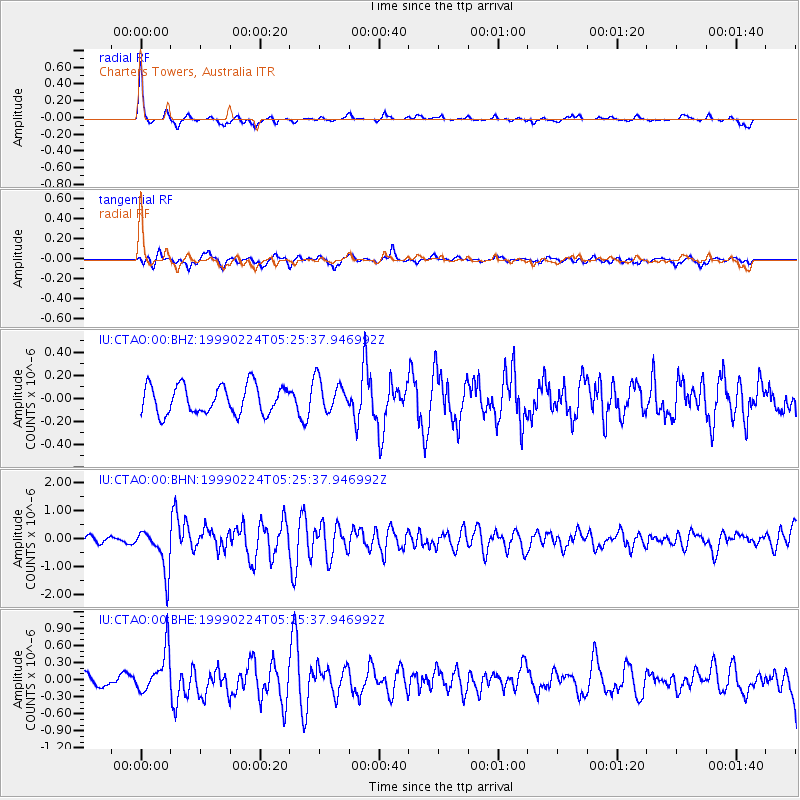
CTAO Charters Towers, Australia - Earthquake Result Viewer
*The percent match for this event was below the threshold and hence no stack was calculated.
| Earthquake location: |
Mariana Islands |
| Earthquake latitude/longitude: |
18.1/146.5 |
| Earthquake time(UTC): |
1999/02/24 (055) 05:18:54 GMT |
| Earthquake Depth: |
33 km |
| Earthquake Magnitude: |
5.6 MS, 5.4 MB, 5.9 MW, 5.7 MW |
| Earthquake Catalog/Contributor: |
WHDF/NEIC |
|
| Network: |
IU Global Seismograph Network (GSN - IRIS/USGS) |
| Station: |
CTAO Charters Towers, Australia |
| Lat/Lon: |
20.09 S/146.25 E |
| Elevation: |
357 m |
|
| Distance: |
37.9 deg |
| Az: |
180.411 deg |
| Baz: |
0.416 deg |
| Ray Param: |
$rayparam |
*The percent match for this event was below the threshold and hence was not used in the summary stack. |
|
| Radial Match: |
79.751595 % |
| Radial Bump: |
275 |
| Transverse Match: |
62.526676 % |
| Transverse Bump: |
400 |
| SOD ConfigId: |
4480 |
| Insert Time: |
2010-03-03 14:36:08.137 +0000 |
| GWidth: |
2.5 |
| Max Bumps: |
400 |
| Tol: |
0.001 |
|
Signal To Noise
| Channel | StoN | STA | LTA |
| IU:CTAO:00:BHN:19990224T05:25:37.946992Z | 5.5346603 | 7.647008E-7 | 1.381658E-7 |
| IU:CTAO:00:BHE:19990224T05:25:37.946992Z | 2.4644713 | 3.657361E-7 | 1.4840347E-7 |
| IU:CTAO:00:BHZ:19990224T05:25:37.946992Z | 1.1540614 | 1.4208203E-7 | 1.231148E-7 |
| Arrivals |
| Ps | |
| PpPs | |
| PsPs/PpSs | |


