You are here: Home > Network List > WY - Yellowstone Wyoming Seismic Network Stations List
> Station YHH Holmes Hill, YNP, WY, USA > Earthquake Result Viewer
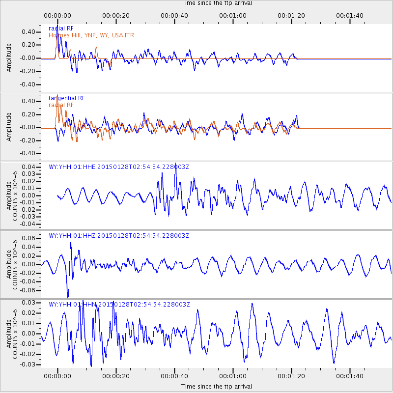
YHH Holmes Hill, YNP, WY, USA - Earthquake Result Viewer
*The percent match for this event was below the threshold and hence no stack was calculated.
| Earthquake location: |
Fiji Islands Region |
| Earthquake latitude/longitude: |
-20.9/-178.4 |
| Earthquake time(UTC): |
2015/01/28 (028) 02:43:19 GMT |
| Earthquake Depth: |
484 km |
| Earthquake Magnitude: |
6.1 MWP |
| Earthquake Catalog/Contributor: |
NEIC PDE/NEIC COMCAT |
|
| Network: |
WY Yellowstone Wyoming Seismic Network |
| Station: |
YHH Holmes Hill, YNP, WY, USA |
| Lat/Lon: |
44.79 N/110.85 W |
| Elevation: |
2717 m |
|
| Distance: |
89.7 deg |
| Az: |
41.139 deg |
| Baz: |
239.747 deg |
| Ray Param: |
$rayparam |
*The percent match for this event was below the threshold and hence was not used in the summary stack. |
|
| Radial Match: |
51.74365 % |
| Radial Bump: |
400 |
| Transverse Match: |
54.62689 % |
| Transverse Bump: |
308 |
| SOD ConfigId: |
837871 |
| Insert Time: |
2015-02-11 05:31:37.739 +0000 |
| GWidth: |
2.5 |
| Max Bumps: |
400 |
| Tol: |
0.001 |
|
Signal To Noise
| Channel | StoN | STA | LTA |
| WY:YHH:01:HHZ:20150128T02:54:54.228003Z | 4.8898497 | 3.0542758E-8 | 6.246155E-9 |
| WY:YHH:01:HHN:20150128T02:54:54.228003Z | 3.0120957 | 1.41354635E-8 | 4.6929E-9 |
| WY:YHH:01:HHE:20150128T02:54:54.228003Z | 1.7029032 | 1.0905315E-8 | 6.4039547E-9 |
| Arrivals |
| Ps | |
| PpPs | |
| PsPs/PpSs | |


