You are here: Home > Network List > NX - Nanometrics Research Network Stations List
> Station STN02 Seismic station 02 > Earthquake Result Viewer
STN02 Seismic station 02 - Earthquake Result Viewer
| Earthquake location: |
Samoa Islands Region |
| Earthquake latitude/longitude: |
-15.6/-173.0 |
| Earthquake time(UTC): |
2015/06/12 (163) 11:07:04 GMT |
| Earthquake Depth: |
29 km |
| Earthquake Magnitude: |
6.3 MO |
| Earthquake Catalog/Contributor: |
NEIC PDE/NEIC ALERT |
|
| Network: |
NX Nanometrics Research Network |
| Station: |
STN02 Seismic station 02 |
| Lat/Lon: |
35.95 N/97.51 W |
| Elevation: |
342 m |
|
| Distance: |
87.7 deg |
| Az: |
51.826 deg |
| Baz: |
249.012 deg |
| Ray Param: |
0.043084305 |
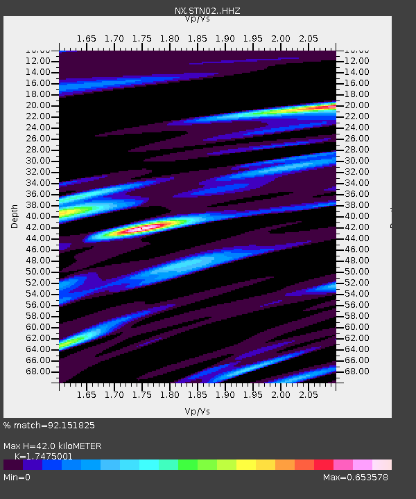
| Estimated Moho Depth: |
42.0 km |
| Estimated Crust Vp/Vs: |
1.75 |
| Assumed Crust Vp: |
6.426 km/s |
| Estimated Crust Vs: |
3.677 km/s |
| Estimated Crust Poisson's Ratio: |
0.26 |
|
| Radial Match: |
92.151825 % |
| Radial Bump: |
311 |
| Transverse Match: |
61.59075 % |
| Transverse Bump: |
400 |
| SOD ConfigId: |
7422571 |
| Insert Time: |
2019-04-19 07:56:36.490 +0000 |
| GWidth: |
2.5 |
| Max Bumps: |
400 |
| Tol: |
0.001 |
|

Signal To Noise
| Channel | StoN | STA | LTA |
| NX:STN02: :HHZ:20150612T11:19:19.759985Z | 10.050842 | 6.0878426E-7 | 6.057047E-8 |
| NX:STN02: :HH1:20150612T11:19:19.759985Z | 2.504151 | 1.7948796E-7 | 7.167617E-8 |
| NX:STN02: :HH2:20150612T11:19:19.759985Z | 1.8126434 | 1.5682933E-7 | 8.651968E-8 |
| Arrivals |
| Ps | 5.0 SECOND |
| PpPs | 18 SECOND |
| PsPs/PpSs | 23 SECOND |


