You are here: Home > Network List > IU - Global Seismograph Network (GSN - IRIS/USGS) Stations List
> Station CTAO Charters Towers, Australia > Earthquake Result Viewer
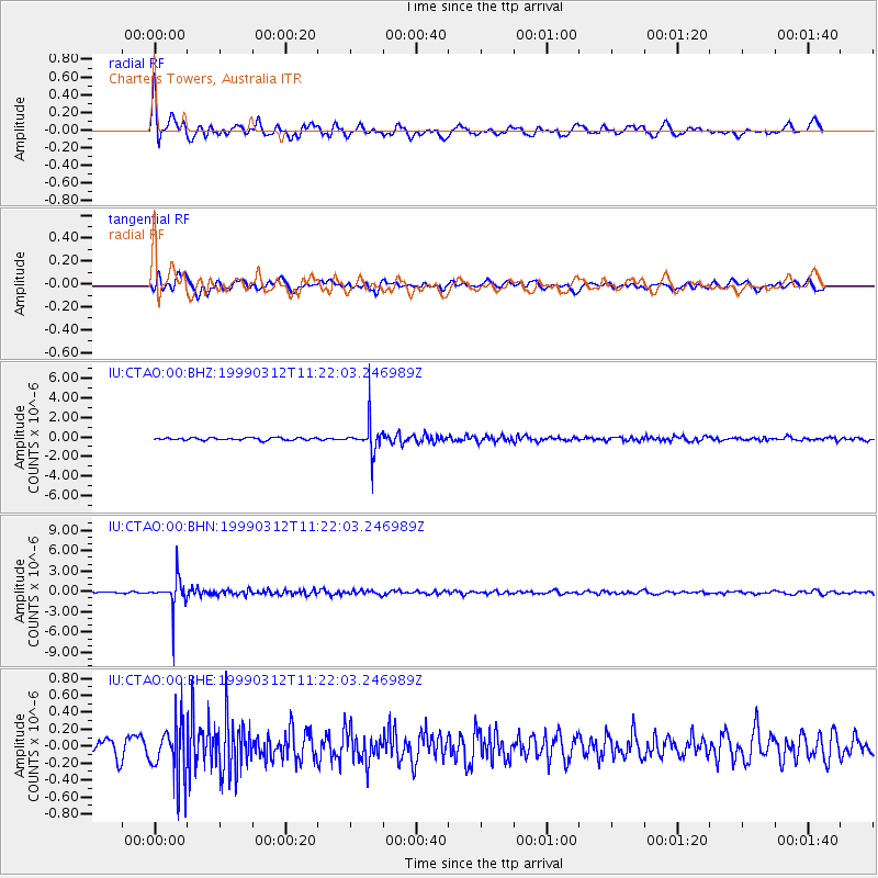
CTAO Charters Towers, Australia - Earthquake Result Viewer
*The percent match for this event was below the threshold and hence no stack was calculated.
| Earthquake location: |
Fiji Islands Region |
| Earthquake latitude/longitude: |
-20.0/-177.8 |
| Earthquake time(UTC): |
1999/03/12 (071) 11:16:39 GMT |
| Earthquake Depth: |
587 km |
| Earthquake Magnitude: |
5.6 MW, 5.2 MB |
| Earthquake Catalog/Contributor: |
WHDF/NEIC |
|
| Network: |
IU Global Seismograph Network (GSN - IRIS/USGS) |
| Station: |
CTAO Charters Towers, Australia |
| Lat/Lon: |
20.09 S/146.25 E |
| Elevation: |
357 m |
|
| Distance: |
33.8 deg |
| Az: |
263.543 deg |
| Baz: |
96.17 deg |
| Ray Param: |
$rayparam |
*The percent match for this event was below the threshold and hence was not used in the summary stack. |
|
| Radial Match: |
79.04505 % |
| Radial Bump: |
400 |
| Transverse Match: |
53.895763 % |
| Transverse Bump: |
400 |
| SOD ConfigId: |
4480 |
| Insert Time: |
2010-03-03 14:36:21.308 +0000 |
| GWidth: |
2.5 |
| Max Bumps: |
400 |
| Tol: |
0.001 |
|
Signal To Noise
| Channel | StoN | STA | LTA |
| IU:CTAO:00:BHN:19990312T11:22:03.246989Z | 15.419756 | 2.2210804E-6 | 1.4404122E-7 |
| IU:CTAO:00:BHE:19990312T11:22:03.246989Z | 2.716594 | 3.2343212E-7 | 1.1905795E-7 |
| IU:CTAO:00:BHZ:19990312T11:22:03.246989Z | 12.812269 | 1.593733E-6 | 1.2439115E-7 |
| Arrivals |
| Ps | |
| PpPs | |
| PsPs/PpSs | |


