You are here: Home > Network List > TA - USArray Transportable Network (new EarthScope stations) Stations List
> Station 121A Cookes Peak, Deming, NM, USA > Earthquake Result Viewer
121A Cookes Peak, Deming, NM, USA - Earthquake Result Viewer
| Earthquake location: |
Samoa Islands Region |
| Earthquake latitude/longitude: |
-15.6/-173.0 |
| Earthquake time(UTC): |
2015/06/12 (163) 11:07:04 GMT |
| Earthquake Depth: |
29 km |
| Earthquake Magnitude: |
6.3 MO |
| Earthquake Catalog/Contributor: |
NEIC PDE/NEIC ALERT |
|
| Network: |
TA USArray Transportable Network (new EarthScope stations) |
| Station: |
121A Cookes Peak, Deming, NM, USA |
| Lat/Lon: |
32.53 N/107.79 W |
| Elevation: |
1652 m |
|
| Distance: |
78.6 deg |
| Az: |
51.483 deg |
| Baz: |
243.2 deg |
| Ray Param: |
0.049520236 |
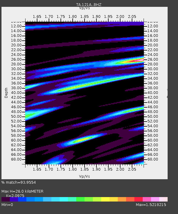
| Estimated Moho Depth: |
26.0 km |
| Estimated Crust Vp/Vs: |
2.10 |
| Assumed Crust Vp: |
6.502 km/s |
| Estimated Crust Vs: |
3.1 km/s |
| Estimated Crust Poisson's Ratio: |
0.35 |
|
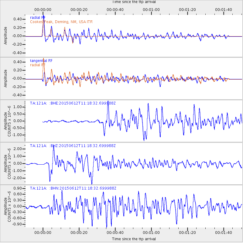
| Radial Match: |
93.9554 % |
| Radial Bump: |
400 |
| Transverse Match: |
84.521935 % |
| Transverse Bump: |
400 |
| SOD ConfigId: |
7422571 |
| Insert Time: |
2019-04-19 07:58:01.673 +0000 |
| GWidth: |
2.5 |
| Max Bumps: |
400 |
| Tol: |
0.001 |
|
Signal To Noise
| Channel | StoN | STA | LTA |
| TA:121A: :BHZ:20150612T11:18:32.699988Z | 16.439499 | 8.15455E-7 | 4.9603393E-8 |
| TA:121A: :BHN:20150612T11:18:32.699988Z | 1.9613339 | 1.1310641E-7 | 5.7668107E-8 |
| TA:121A: :BHE:20150612T11:18:32.699988Z | 8.470886 | 3.3017133E-7 | 3.8977188E-8 |
| Arrivals |
| Ps | 4.5 SECOND |
| PpPs | 12 SECOND |
| PsPs/PpSs | 17 SECOND |


