You are here: Home > Network List > TA - USArray Transportable Network (new EarthScope stations) Stations List
> Station A36M Sachs Harbour, NT, CAN > Earthquake Result Viewer
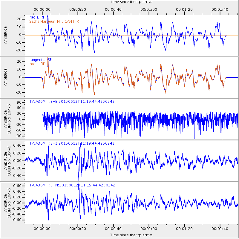
A36M Sachs Harbour, NT, CAN - Earthquake Result Viewer
*The percent match for this event was below the threshold and hence no stack was calculated.
| Earthquake location: |
Samoa Islands Region |
| Earthquake latitude/longitude: |
-15.6/-173.0 |
| Earthquake time(UTC): |
2015/06/12 (163) 11:07:04 GMT |
| Earthquake Depth: |
29 km |
| Earthquake Magnitude: |
6.3 MO |
| Earthquake Catalog/Contributor: |
NEIC PDE/NEIC ALERT |
|
| Network: |
TA USArray Transportable Network (new EarthScope stations) |
| Station: |
A36M Sachs Harbour, NT, CAN |
| Lat/Lon: |
71.99 N/125.25 W |
| Elevation: |
32 m |
|
| Distance: |
93.0 deg |
| Az: |
13.333 deg |
| Baz: |
225.585 deg |
| Ray Param: |
$rayparam |
*The percent match for this event was below the threshold and hence was not used in the summary stack. |
|
| Radial Match: |
53.45917 % |
| Radial Bump: |
400 |
| Transverse Match: |
53.23492 % |
| Transverse Bump: |
400 |
| SOD ConfigId: |
7422571 |
| Insert Time: |
2019-04-19 07:58:05.493 +0000 |
| GWidth: |
2.5 |
| Max Bumps: |
400 |
| Tol: |
0.001 |
|
Signal To Noise
| Channel | StoN | STA | LTA |
| TA:A36M: :BHZ:20150612T11:19:44.425024Z | 2.3383262 | 1.7420516E-7 | 7.449993E-8 |
| TA:A36M: :BHN:20150612T11:19:44.425024Z | 2.8198166 | 1.9498877E-7 | 6.914945E-8 |
| TA:A36M: :BHE:20150612T11:19:44.425024Z | 0.8100999 | 2.2269414E-5 | 2.7489712E-5 |
| Arrivals |
| Ps | |
| PpPs | |
| PsPs/PpSs | |


