You are here: Home > Network List > TA - USArray Transportable Network (new EarthScope stations) Stations List
> Station F05D White Salmon, WA, USA > Earthquake Result Viewer
F05D White Salmon, WA, USA - Earthquake Result Viewer
| Earthquake location: |
Samoa Islands Region |
| Earthquake latitude/longitude: |
-15.6/-173.0 |
| Earthquake time(UTC): |
2015/06/12 (163) 11:07:04 GMT |
| Earthquake Depth: |
29 km |
| Earthquake Magnitude: |
6.3 MO |
| Earthquake Catalog/Contributor: |
NEIC PDE/NEIC ALERT |
|
| Network: |
TA USArray Transportable Network (new EarthScope stations) |
| Station: |
F05D White Salmon, WA, USA |
| Lat/Lon: |
45.89 N/121.46 W |
| Elevation: |
472 m |
|
| Distance: |
76.9 deg |
| Az: |
34.171 deg |
| Baz: |
230.793 deg |
| Ray Param: |
0.05068037 |
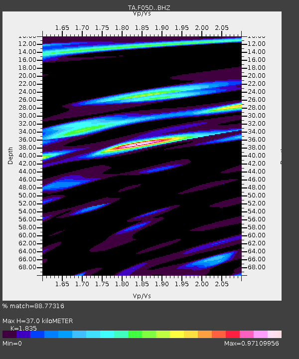
| Estimated Moho Depth: |
37.0 km |
| Estimated Crust Vp/Vs: |
1.84 |
| Assumed Crust Vp: |
6.597 km/s |
| Estimated Crust Vs: |
3.595 km/s |
| Estimated Crust Poisson's Ratio: |
0.29 |
|
| Radial Match: |
88.77316 % |
| Radial Bump: |
400 |
| Transverse Match: |
83.41575 % |
| Transverse Bump: |
400 |
| SOD ConfigId: |
7422571 |
| Insert Time: |
2019-04-19 07:58:13.007 +0000 |
| GWidth: |
2.5 |
| Max Bumps: |
400 |
| Tol: |
0.001 |
|

Signal To Noise
| Channel | StoN | STA | LTA |
| TA:F05D: :BHZ:20150612T11:18:23.275Z | 11.723956 | 1.3314456E-6 | 1.1356624E-7 |
| TA:F05D: :BHN:20150612T11:18:23.275Z | 1.635915 | 3.0686812E-7 | 1.8758193E-7 |
| TA:F05D: :BHE:20150612T11:18:23.275Z | 3.3298557 | 3.2011746E-7 | 9.6135544E-8 |
| Arrivals |
| Ps | 4.8 SECOND |
| PpPs | 15 SECOND |
| PsPs/PpSs | 20 SECOND |


