You are here: Home > Network List > IU - Global Seismograph Network (GSN - IRIS/USGS) Stations List
> Station CTAO Charters Towers, Australia > Earthquake Result Viewer
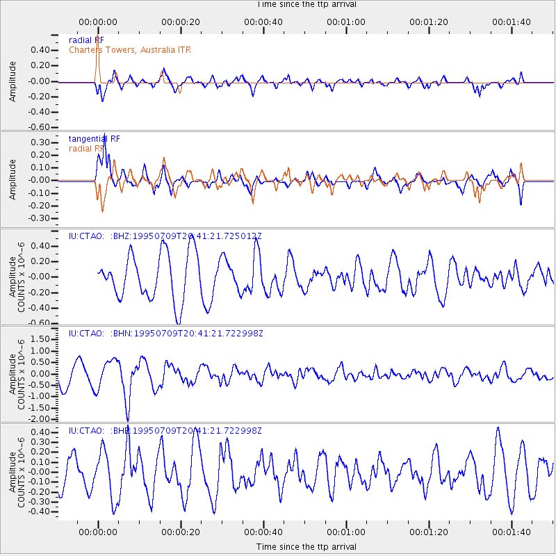
CTAO Charters Towers, Australia - Earthquake Result Viewer
*The percent match for this event was below the threshold and hence no stack was calculated.
| Earthquake location: |
Myanmar-China Border Region |
| Earthquake latitude/longitude: |
22.0/99.2 |
| Earthquake time(UTC): |
1995/07/09 (190) 20:31:31 GMT |
| Earthquake Depth: |
12 km |
| Earthquake Magnitude: |
5.7 MB, 5.9 MS, 5.6 UNKNOWN, 6.2 MW |
| Earthquake Catalog/Contributor: |
WHDF/NEIC |
|
| Network: |
IU Global Seismograph Network (GSN - IRIS/USGS) |
| Station: |
CTAO Charters Towers, Australia |
| Lat/Lon: |
20.09 S/146.25 E |
| Elevation: |
357 m |
|
| Distance: |
62.2 deg |
| Az: |
128.909 deg |
| Baz: |
309.797 deg |
| Ray Param: |
$rayparam |
*The percent match for this event was below the threshold and hence was not used in the summary stack. |
|
| Radial Match: |
51.356804 % |
| Radial Bump: |
400 |
| Transverse Match: |
82.14481 % |
| Transverse Bump: |
400 |
| SOD ConfigId: |
4480 |
| Insert Time: |
2010-03-03 14:36:37.406 +0000 |
| GWidth: |
2.5 |
| Max Bumps: |
400 |
| Tol: |
0.001 |
|
Signal To Noise
| Channel | StoN | STA | LTA |
| IU:CTAO: :BHN:19950709T20:41:21.722998Z | 1.7299659 | 6.347108E-7 | 3.6689207E-7 |
| IU:CTAO: :BHE:19950709T20:41:21.722998Z | 1.7589338 | 2.4830484E-7 | 1.4116782E-7 |
| IU:CTAO: :BHZ:19950709T20:41:21.725012Z | 0.6727574 | 1.9990097E-7 | 2.9713678E-7 |
| Arrivals |
| Ps | |
| PpPs | |
| PsPs/PpSs | |


