You are here: Home > Network List > TA - USArray Transportable Network (new EarthScope stations) Stations List
> Station N25K Chitina, Valdez-Cordova, AK, USA > Earthquake Result Viewer
N25K Chitina, Valdez-Cordova, AK, USA - Earthquake Result Viewer
| Earthquake location: |
Samoa Islands Region |
| Earthquake latitude/longitude: |
-15.6/-173.0 |
| Earthquake time(UTC): |
2015/06/12 (163) 11:07:04 GMT |
| Earthquake Depth: |
29 km |
| Earthquake Magnitude: |
6.3 MO |
| Earthquake Catalog/Contributor: |
NEIC PDE/NEIC ALERT |
|
| Network: |
TA USArray Transportable Network (new EarthScope stations) |
| Station: |
N25K Chitina, Valdez-Cordova, AK, USA |
| Lat/Lon: |
61.61 N/144.60 W |
| Elevation: |
1087 m |
|
| Distance: |
80.2 deg |
| Az: |
13.34 deg |
| Baz: |
207.719 deg |
| Ray Param: |
0.048416175 |
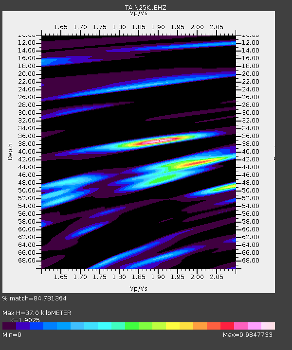
| Estimated Moho Depth: |
37.0 km |
| Estimated Crust Vp/Vs: |
1.90 |
| Assumed Crust Vp: |
6.566 km/s |
| Estimated Crust Vs: |
3.451 km/s |
| Estimated Crust Poisson's Ratio: |
0.31 |
|
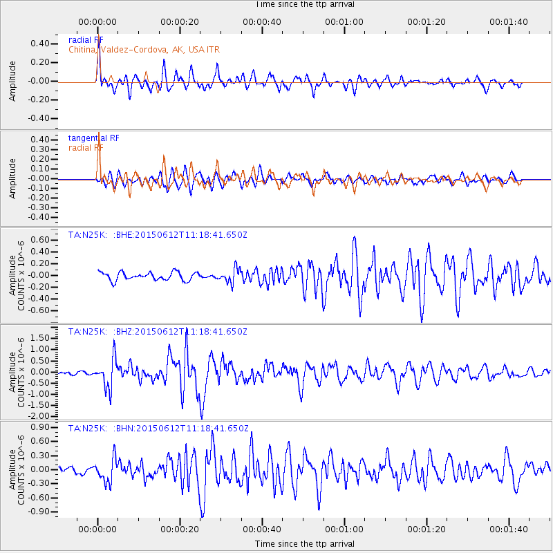
| Radial Match: |
84.781364 % |
| Radial Bump: |
400 |
| Transverse Match: |
74.53412 % |
| Transverse Bump: |
400 |
| SOD ConfigId: |
7422571 |
| Insert Time: |
2019-04-19 07:58:39.865 +0000 |
| GWidth: |
2.5 |
| Max Bumps: |
400 |
| Tol: |
0.001 |
|
Signal To Noise
| Channel | StoN | STA | LTA |
| TA:N25K: :BHZ:20150612T11:18:41.650Z | 8.709863 | 6.60031E-7 | 7.577972E-8 |
| TA:N25K: :BHN:20150612T11:18:41.650Z | 3.5266585 | 2.5018437E-7 | 7.094091E-8 |
| TA:N25K: :BHE:20150612T11:18:41.650Z | 1.6910684 | 1.1541109E-7 | 6.8247445E-8 |
| Arrivals |
| Ps | 5.2 SECOND |
| PpPs | 16 SECOND |
| PsPs/PpSs | 21 SECOND |


