You are here: Home > Network List > TA - USArray Transportable Network (new EarthScope stations) Stations List
> Station O48A Farmland, IN, USA > Earthquake Result Viewer
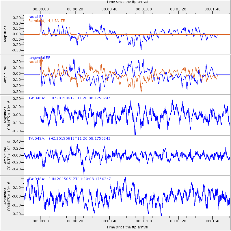
O48A Farmland, IN, USA - Earthquake Result Viewer
*The percent match for this event was below the threshold and hence no stack was calculated.
| Earthquake location: |
Samoa Islands Region |
| Earthquake latitude/longitude: |
-15.6/-173.0 |
| Earthquake time(UTC): |
2015/06/12 (163) 11:07:04 GMT |
| Earthquake Depth: |
29 km |
| Earthquake Magnitude: |
6.3 MO |
| Earthquake Catalog/Contributor: |
NEIC PDE/NEIC ALERT |
|
| Network: |
TA USArray Transportable Network (new EarthScope stations) |
| Station: |
O48A Farmland, IN, USA |
| Lat/Lon: |
40.26 N/85.16 W |
| Elevation: |
300 m |
|
| Distance: |
98.3 deg |
| Az: |
50.608 deg |
| Baz: |
256.69 deg |
| Ray Param: |
$rayparam |
*The percent match for this event was below the threshold and hence was not used in the summary stack. |
|
| Radial Match: |
63.397366 % |
| Radial Bump: |
400 |
| Transverse Match: |
64.537476 % |
| Transverse Bump: |
400 |
| SOD ConfigId: |
7422571 |
| Insert Time: |
2019-04-19 07:58:44.222 +0000 |
| GWidth: |
2.5 |
| Max Bumps: |
400 |
| Tol: |
0.001 |
|
Signal To Noise
| Channel | StoN | STA | LTA |
| TA:O48A: :BHZ:20150612T11:20:08.175024Z | 2.682349 | 1.6010287E-7 | 5.9687565E-8 |
| TA:O48A: :BHN:20150612T11:20:08.175024Z | 1.0461916 | 7.463521E-8 | 7.1339905E-8 |
| TA:O48A: :BHE:20150612T11:20:08.175024Z | 1.2103618 | 6.8954876E-8 | 5.697046E-8 |
| Arrivals |
| Ps | |
| PpPs | |
| PsPs/PpSs | |


