You are here: Home > Network List > TD - TransAlta Monitoring Network Stations List
> Station TD008 Z > Earthquake Result Viewer
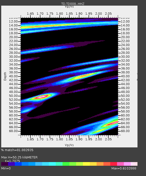
TD008 Z - Earthquake Result Viewer
| Earthquake location: |
Samoa Islands Region |
| Earthquake latitude/longitude: |
-15.6/-173.0 |
| Earthquake time(UTC): |
2015/06/12 (163) 11:07:04 GMT |
| Earthquake Depth: |
29 km |
| Earthquake Magnitude: |
6.3 MO |
| Earthquake Catalog/Contributor: |
NEIC PDE/NEIC ALERT |
|
| Network: |
TD TransAlta Monitoring Network |
| Station: |
TD008 Z |
| Lat/Lon: |
52.80 N/115.43 W |
| Elevation: |
964 m |
|
| Distance: |
84.2 deg |
| Az: |
31.002 deg |
| Baz: |
234.84 deg |
| Ray Param: |
0.045634463 |
| Estimated Moho Depth: |
50.25 km |
| Estimated Crust Vp/Vs: |
1.71 |
| Assumed Crust Vp: |
6.426 km/s |
| Estimated Crust Vs: |
3.763 km/s |
| Estimated Crust Poisson's Ratio: |
0.24 |
|
| Radial Match: |
81.882935 % |
| Radial Bump: |
400 |
| Transverse Match: |
80.41385 % |
| Transverse Bump: |
400 |
| SOD ConfigId: |
7422571 |
| Insert Time: |
2019-04-19 07:59:07.093 +0000 |
| GWidth: |
2.5 |
| Max Bumps: |
400 |
| Tol: |
0.001 |
|

Signal To Noise
| Channel | StoN | STA | LTA |
| TD:TD008: :HHZ:20150612T11:19:02.37998Z | 14.407109 | 1.4112574E-6 | 9.795563E-8 |
| TD:TD008: :HH1:20150612T11:19:02.37998Z | 1.4096953 | 1.9914471E-7 | 1.412679E-7 |
| TD:TD008: :HH2:20150612T11:19:02.37998Z | 1.8662826 | 2.2946135E-7 | 1.2295102E-7 |
| Arrivals |
| Ps | 5.7 SECOND |
| PpPs | 21 SECOND |
| PsPs/PpSs | 26 SECOND |


