You are here: Home > Network List > TO - Tectonic Observatory Stations List
> Station CC34 CCSE CC34 > Earthquake Result Viewer
CC34 CCSE CC34 - Earthquake Result Viewer
| Earthquake location: |
Samoa Islands Region |
| Earthquake latitude/longitude: |
-15.6/-173.0 |
| Earthquake time(UTC): |
2015/06/12 (163) 11:07:04 GMT |
| Earthquake Depth: |
29 km |
| Earthquake Magnitude: |
6.3 MO |
| Earthquake Catalog/Contributor: |
NEIC PDE/NEIC ALERT |
|
| Network: |
TO Tectonic Observatory |
| Station: |
CC34 CCSE CC34 |
| Lat/Lon: |
36.36 N/119.06 W |
| Elevation: |
173 m |
|
| Distance: |
72.5 deg |
| Az: |
43.164 deg |
| Baz: |
234.753 deg |
| Ray Param: |
0.05356052 |
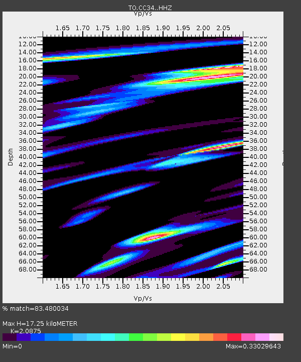
| Estimated Moho Depth: |
17.25 km |
| Estimated Crust Vp/Vs: |
2.09 |
| Assumed Crust Vp: |
6.291 km/s |
| Estimated Crust Vs: |
3.014 km/s |
| Estimated Crust Poisson's Ratio: |
0.35 |
|
| Radial Match: |
83.480034 % |
| Radial Bump: |
312 |
| Transverse Match: |
65.43578 % |
| Transverse Bump: |
400 |
| SOD ConfigId: |
7422571 |
| Insert Time: |
2019-04-19 07:59:30.897 +0000 |
| GWidth: |
2.5 |
| Max Bumps: |
400 |
| Tol: |
0.001 |
|

Signal To Noise
| Channel | StoN | STA | LTA |
| TO:CC34: :HHZ:20150612T11:17:58.280005Z | 15.093194 | 1.1759964E-6 | 7.791568E-8 |
| TO:CC34: :HHN:20150612T11:17:58.280005Z | 2.9741883 | 3.348935E-7 | 1.1259996E-7 |
| TO:CC34: :HHE:20150612T11:17:58.280005Z | 3.8552072 | 3.1286896E-7 | 8.11549E-8 |
| Arrivals |
| Ps | 3.1 SECOND |
| PpPs | 8.2 SECOND |
| PsPs/PpSs | 11 SECOND |


