You are here: Home > Network List > IU - Global Seismograph Network (GSN - IRIS/USGS) Stations List
> Station CTAO Charters Towers, Australia > Earthquake Result Viewer
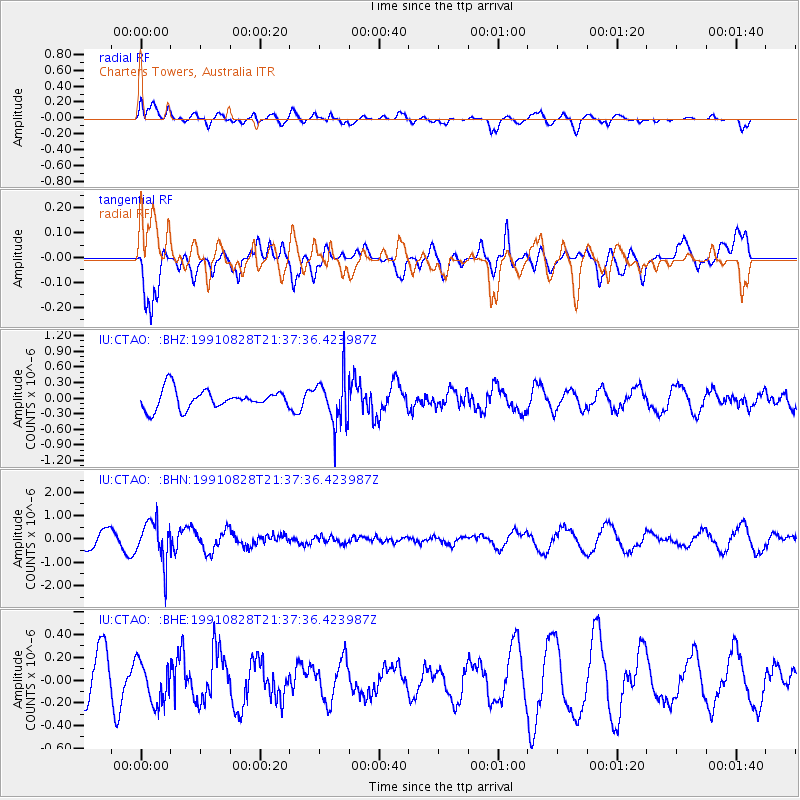
CTAO Charters Towers, Australia - Earthquake Result Viewer
*The percent match for this event was below the threshold and hence no stack was calculated.
| Earthquake location: |
South Of Fiji Islands |
| Earthquake latitude/longitude: |
-22.1/179.6 |
| Earthquake time(UTC): |
1991/08/28 (240) 21:32:35 GMT |
| Earthquake Depth: |
608 km |
| Earthquake Magnitude: |
5.5 MB |
| Earthquake Catalog/Contributor: |
WHDF/NEIC |
|
| Network: |
IU Global Seismograph Network (GSN - IRIS/USGS) |
| Station: |
CTAO Charters Towers, Australia |
| Lat/Lon: |
20.09 S/146.25 E |
| Elevation: |
357 m |
|
| Distance: |
31.1 deg |
| Az: |
267.445 deg |
| Baz: |
99.673 deg |
| Ray Param: |
$rayparam |
*The percent match for this event was below the threshold and hence was not used in the summary stack. |
|
| Radial Match: |
55.885773 % |
| Radial Bump: |
400 |
| Transverse Match: |
78.18214 % |
| Transverse Bump: |
400 |
| SOD ConfigId: |
4480 |
| Insert Time: |
2010-03-03 14:36:53.317 +0000 |
| GWidth: |
2.5 |
| Max Bumps: |
400 |
| Tol: |
0.001 |
|
Signal To Noise
| Channel | StoN | STA | LTA |
| IU:CTAO: :BHN:19910828T21:37:36.423987Z | 3.404408 | 8.7460126E-7 | 2.5690258E-7 |
| IU:CTAO: :BHE:19910828T21:37:36.423987Z | 1.1346337 | 1.8547655E-7 | 1.6346821E-7 |
| IU:CTAO: :BHZ:19910828T21:37:36.423987Z | 2.5166898 | 4.590551E-7 | 1.8240432E-7 |
| Arrivals |
| Ps | |
| PpPs | |
| PsPs/PpSs | |


