You are here: Home > Network List > UO - University of Oregon Regional Network Stations List
> Station PINE Pine Mountain Observatory, OR > Earthquake Result Viewer
PINE Pine Mountain Observatory, OR - Earthquake Result Viewer
| Earthquake location: |
Samoa Islands Region |
| Earthquake latitude/longitude: |
-15.6/-173.0 |
| Earthquake time(UTC): |
2015/06/12 (163) 11:07:04 GMT |
| Earthquake Depth: |
29 km |
| Earthquake Magnitude: |
6.3 MO |
| Earthquake Catalog/Contributor: |
NEIC PDE/NEIC ALERT |
|
| Network: |
UO University of Oregon Regional Network |
| Station: |
PINE Pine Mountain Observatory, OR |
| Lat/Lon: |
43.79 N/120.94 W |
| Elevation: |
1916 m |
|
| Distance: |
75.8 deg |
| Az: |
36.088 deg |
| Baz: |
231.611 deg |
| Ray Param: |
0.05136877 |
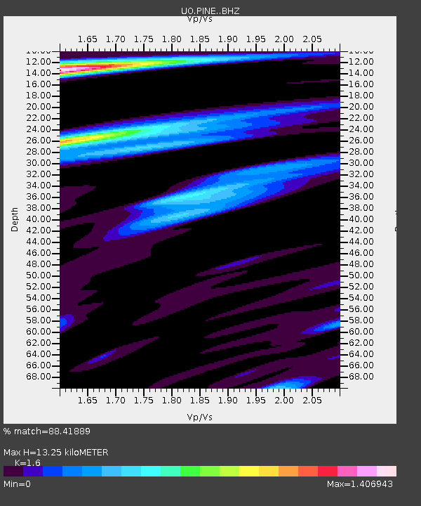
| Estimated Moho Depth: |
13.25 km |
| Estimated Crust Vp/Vs: |
1.60 |
| Assumed Crust Vp: |
6.597 km/s |
| Estimated Crust Vs: |
4.123 km/s |
| Estimated Crust Poisson's Ratio: |
0.18 |
|
| Radial Match: |
88.41889 % |
| Radial Bump: |
400 |
| Transverse Match: |
78.56814 % |
| Transverse Bump: |
400 |
| SOD ConfigId: |
7422571 |
| Insert Time: |
2019-04-19 07:59:39.715 +0000 |
| GWidth: |
2.5 |
| Max Bumps: |
400 |
| Tol: |
0.001 |
|

Signal To Noise
| Channel | StoN | STA | LTA |
| UO:PINE: :BHZ:20150612T11:18:17.480017Z | 14.847135 | 1.5932932E-6 | 1.0731318E-7 |
| UO:PINE: :BHN:20150612T11:18:17.480017Z | 1.9305307 | 3.7013953E-7 | 1.9172943E-7 |
| UO:PINE: :BHE:20150612T11:18:17.480017Z | 4.417618 | 5.7994293E-7 | 1.3127956E-7 |
| Arrivals |
| Ps | 1.3 SECOND |
| PpPs | 5.0 SECOND |
| PsPs/PpSs | 6.3 SECOND |


