You are here: Home > Network List > IU - Global Seismograph Network (GSN - IRIS/USGS) Stations List
> Station CTAO Charters Towers, Australia > Earthquake Result Viewer
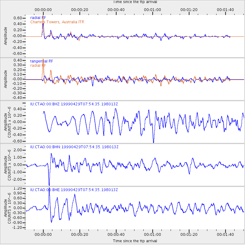
CTAO Charters Towers, Australia - Earthquake Result Viewer
*The percent match for this event was below the threshold and hence no stack was calculated.
| Earthquake location: |
Southeast Of Ryukyu Islands |
| Earthquake latitude/longitude: |
28.9/131.1 |
| Earthquake time(UTC): |
1999/04/29 (119) 07:46:08 GMT |
| Earthquake Depth: |
33 km |
| Earthquake Magnitude: |
5.8 MB, 5.5 MS, 5.9 MW, 5.9 MW |
| Earthquake Catalog/Contributor: |
WHDF/NEIC |
|
| Network: |
IU Global Seismograph Network (GSN - IRIS/USGS) |
| Station: |
CTAO Charters Towers, Australia |
| Lat/Lon: |
20.09 S/146.25 E |
| Elevation: |
357 m |
|
| Distance: |
50.8 deg |
| Az: |
161.576 deg |
| Baz: |
342.846 deg |
| Ray Param: |
$rayparam |
*The percent match for this event was below the threshold and hence was not used in the summary stack. |
|
| Radial Match: |
59.176613 % |
| Radial Bump: |
323 |
| Transverse Match: |
47.72666 % |
| Transverse Bump: |
400 |
| SOD ConfigId: |
4480 |
| Insert Time: |
2010-03-03 14:36:56.830 +0000 |
| GWidth: |
2.5 |
| Max Bumps: |
400 |
| Tol: |
0.001 |
|
Signal To Noise
| Channel | StoN | STA | LTA |
| IU:CTAO:00:BHN:19990429T07:54:35.198013Z | 7.684425 | 9.581446E-7 | 1.2468657E-7 |
| IU:CTAO:00:BHE:19990429T07:54:35.198013Z | 2.8904202 | 4.568291E-7 | 1.5804937E-7 |
| IU:CTAO:00:BHZ:19990429T07:54:35.198013Z | 1.3204106 | 2.306443E-7 | 1.7467619E-7 |
| Arrivals |
| Ps | |
| PpPs | |
| PsPs/PpSs | |


