You are here: Home > Network List > IU - Global Seismograph Network (GSN - IRIS/USGS) Stations List
> Station CTAO Charters Towers, Australia > Earthquake Result Viewer
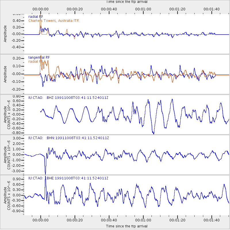
CTAO Charters Towers, Australia - Earthquake Result Viewer
*The percent match for this event was below the threshold and hence no stack was calculated.
| Earthquake location: |
Kuril Islands |
| Earthquake latitude/longitude: |
45.6/149.0 |
| Earthquake time(UTC): |
1991/10/08 (281) 03:31:15 GMT |
| Earthquake Depth: |
147 km |
| Earthquake Magnitude: |
6.0 MB, 5.3 UNKNOWN |
| Earthquake Catalog/Contributor: |
WHDF/NEIC |
|
| Network: |
IU Global Seismograph Network (GSN - IRIS/USGS) |
| Station: |
CTAO Charters Towers, Australia |
| Lat/Lon: |
20.09 S/146.25 E |
| Elevation: |
357 m |
|
| Distance: |
65.4 deg |
| Az: |
182.879 deg |
| Baz: |
2.152 deg |
| Ray Param: |
$rayparam |
*The percent match for this event was below the threshold and hence was not used in the summary stack. |
|
| Radial Match: |
74.67989 % |
| Radial Bump: |
400 |
| Transverse Match: |
44.105602 % |
| Transverse Bump: |
400 |
| SOD ConfigId: |
4480 |
| Insert Time: |
2010-03-03 14:36:57.482 +0000 |
| GWidth: |
2.5 |
| Max Bumps: |
400 |
| Tol: |
0.001 |
|
Signal To Noise
| Channel | StoN | STA | LTA |
| IU:CTAO: :BHN:19911008T03:41:11.524011Z | 6.766823 | 1.1347108E-6 | 1.6768739E-7 |
| IU:CTAO: :BHE:19911008T03:41:11.524011Z | 2.5565715 | 3.541022E-7 | 1.3850668E-7 |
| IU:CTAO: :BHZ:19911008T03:41:11.524011Z | 1.090374 | 2.2105776E-7 | 2.0273572E-7 |
| Arrivals |
| Ps | |
| PpPs | |
| PsPs/PpSs | |


