You are here: Home > Network List > IU - Global Seismograph Network (GSN - IRIS/USGS) Stations List
> Station CTAO Charters Towers, Australia > Earthquake Result Viewer
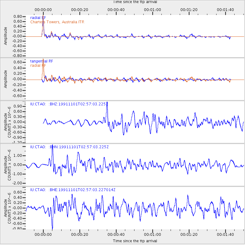
CTAO Charters Towers, Australia - Earthquake Result Viewer
*The percent match for this event was below the threshold and hence no stack was calculated.
| Earthquake location: |
Minahassa Peninsula, Sulawesi |
| Earthquake latitude/longitude: |
1.2/122.1 |
| Earthquake time(UTC): |
1991/11/01 (305) 02:51:12 GMT |
| Earthquake Depth: |
38 km |
| Earthquake Magnitude: |
5.5 MB, 5.6 MS |
| Earthquake Catalog/Contributor: |
WHDF/NEIC |
|
| Network: |
IU Global Seismograph Network (GSN - IRIS/USGS) |
| Station: |
CTAO Charters Towers, Australia |
| Lat/Lon: |
20.09 S/146.25 E |
| Elevation: |
357 m |
|
| Distance: |
31.8 deg |
| Az: |
133.09 deg |
| Baz: |
309.032 deg |
| Ray Param: |
$rayparam |
*The percent match for this event was below the threshold and hence was not used in the summary stack. |
|
| Radial Match: |
79.662766 % |
| Radial Bump: |
283 |
| Transverse Match: |
68.81084 % |
| Transverse Bump: |
400 |
| SOD ConfigId: |
4480 |
| Insert Time: |
2010-03-03 14:36:59.354 +0000 |
| GWidth: |
2.5 |
| Max Bumps: |
400 |
| Tol: |
0.001 |
|
Signal To Noise
| Channel | StoN | STA | LTA |
| IU:CTAO: :BHN:19911101T02:57:03.225Z | 3.343263 | 4.3735758E-7 | 1.3081758E-7 |
| IU:CTAO: :BHE:19911101T02:57:03.227014Z | 2.194692 | 1.8616792E-7 | 8.482645E-8 |
| IU:CTAO: :BHZ:19911101T02:57:03.225Z | 2.3901982 | 2.1813773E-7 | 9.1263445E-8 |
| Arrivals |
| Ps | |
| PpPs | |
| PsPs/PpSs | |


