You are here: Home > Network List > IU - Global Seismograph Network (GSN - IRIS/USGS) Stations List
> Station CTAO Charters Towers, Australia > Earthquake Result Viewer
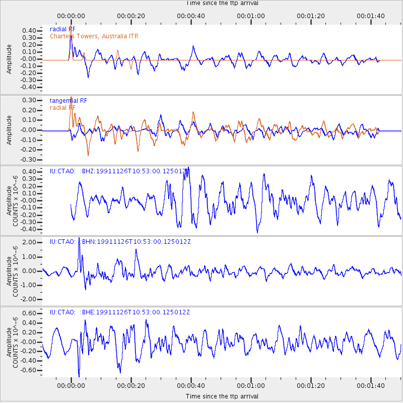
CTAO Charters Towers, Australia - Earthquake Result Viewer
*The percent match for this event was below the threshold and hence no stack was calculated.
| Earthquake location: |
Andreanof Islands, Aleutian Is. |
| Earthquake latitude/longitude: |
51.8/-176.1 |
| Earthquake time(UTC): |
1991/11/26 (330) 10:41:35 GMT |
| Earthquake Depth: |
69 km |
| Earthquake Magnitude: |
5.8 MB |
| Earthquake Catalog/Contributor: |
WHDF/NEIC |
|
| Network: |
IU Global Seismograph Network (GSN - IRIS/USGS) |
| Station: |
CTAO Charters Towers, Australia |
| Lat/Lon: |
20.09 S/146.25 E |
| Elevation: |
357 m |
|
| Distance: |
78.8 deg |
| Az: |
215.8 deg |
| Baz: |
22.721 deg |
| Ray Param: |
$rayparam |
*The percent match for this event was below the threshold and hence was not used in the summary stack. |
|
| Radial Match: |
63.35667 % |
| Radial Bump: |
400 |
| Transverse Match: |
64.50928 % |
| Transverse Bump: |
400 |
| SOD ConfigId: |
4480 |
| Insert Time: |
2010-03-03 14:37:01.025 +0000 |
| GWidth: |
2.5 |
| Max Bumps: |
400 |
| Tol: |
0.001 |
|
Signal To Noise
| Channel | StoN | STA | LTA |
| IU:CTAO: :BHN:19911126T10:53:00.125012Z | 3.2832325 | 7.843874E-7 | 2.3890706E-7 |
| IU:CTAO: :BHE:19911126T10:53:00.125012Z | 1.2144438 | 2.509821E-7 | 2.0666424E-7 |
| IU:CTAO: :BHZ:19911126T10:53:00.125012Z | 1.5310675 | 1.5584426E-7 | 1.0178798E-7 |
| Arrivals |
| Ps | |
| PpPs | |
| PsPs/PpSs | |


