You are here: Home > Network List > XD14 - Illuminating the architecture of the greater Mount St. Helens magmatic systems f Stations List
> Station MQ07 "Mount St Helens, WA" > Earthquake Result Viewer
MQ07 "Mount St Helens, WA" - Earthquake Result Viewer
| Earthquake location: |
Samoa Islands Region |
| Earthquake latitude/longitude: |
-15.6/-173.0 |
| Earthquake time(UTC): |
2015/06/12 (163) 11:07:04 GMT |
| Earthquake Depth: |
29 km |
| Earthquake Magnitude: |
6.3 MO |
| Earthquake Catalog/Contributor: |
NEIC PDE/NEIC ALERT |
|
| Network: |
XD Illuminating the architecture of the greater Mount St. Helens magmatic systems f |
| Station: |
MQ07 "Mount St Helens, WA" |
| Lat/Lon: |
45.81 N/122.11 W |
| Elevation: |
1037 m |
|
| Distance: |
76.5 deg |
| Az: |
33.936 deg |
| Baz: |
230.276 deg |
| Ray Param: |
0.050947763 |
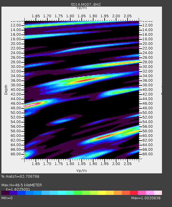
| Estimated Moho Depth: |
46.5 km |
| Estimated Crust Vp/Vs: |
1.62 |
| Assumed Crust Vp: |
6.566 km/s |
| Estimated Crust Vs: |
4.047 km/s |
| Estimated Crust Poisson's Ratio: |
0.19 |
|
| Radial Match: |
82.708786 % |
| Radial Bump: |
400 |
| Transverse Match: |
85.030785 % |
| Transverse Bump: |
400 |
| SOD ConfigId: |
7422571 |
| Insert Time: |
2019-04-19 08:01:13.562 +0000 |
| GWidth: |
2.5 |
| Max Bumps: |
400 |
| Tol: |
0.001 |
|

Signal To Noise
| Channel | StoN | STA | LTA |
| XD:MQ07: :BHZ:20150612T11:18:21.030005Z | 15.706067 | 1.833297E-6 | 1.167254E-7 |
| XD:MQ07: :BHN:20150612T11:18:21.030005Z | 5.3103213 | 6.368911E-7 | 1.1993458E-7 |
| XD:MQ07: :BHE:20150612T11:18:21.030005Z | 5.6833644 | 7.867552E-7 | 1.3843123E-7 |
| Arrivals |
| Ps | 4.6 SECOND |
| PpPs | 18 SECOND |
| PsPs/PpSs | 22 SECOND |


