You are here: Home > Network List > YN10 - San Jacinto Fault Zone Stations List
> Station JFN2 JFN2 > Earthquake Result Viewer
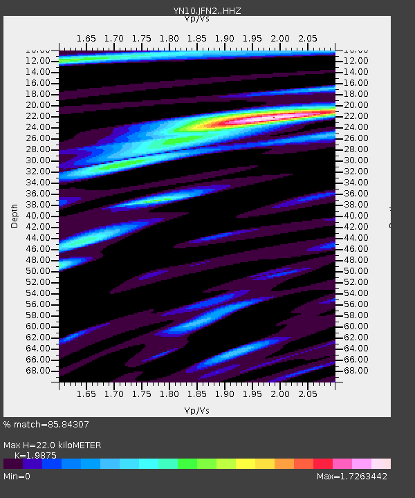
JFN2 JFN2 - Earthquake Result Viewer
| Earthquake location: |
Samoa Islands Region |
| Earthquake latitude/longitude: |
-15.6/-173.0 |
| Earthquake time(UTC): |
2015/06/12 (163) 11:07:04 GMT |
| Earthquake Depth: |
29 km |
| Earthquake Magnitude: |
6.3 MO |
| Earthquake Catalog/Contributor: |
NEIC PDE/NEIC ALERT |
|
| Network: |
YN San Jacinto Fault Zone |
| Station: |
JFN2 JFN2 |
| Lat/Lon: |
33.43 N/116.40 W |
| Elevation: |
644 m |
|
| Distance: |
72.7 deg |
| Az: |
46.985 deg |
| Baz: |
237.407 deg |
| Ray Param: |
0.053444564 |
| Estimated Moho Depth: |
22.0 km |
| Estimated Crust Vp/Vs: |
1.99 |
| Assumed Crust Vp: |
6.264 km/s |
| Estimated Crust Vs: |
3.152 km/s |
| Estimated Crust Poisson's Ratio: |
0.33 |
|
| Radial Match: |
85.84307 % |
| Radial Bump: |
400 |
| Transverse Match: |
84.20634 % |
| Transverse Bump: |
400 |
| SOD ConfigId: |
7422571 |
| Insert Time: |
2019-04-19 08:01:24.801 +0000 |
| GWidth: |
2.5 |
| Max Bumps: |
400 |
| Tol: |
0.001 |
|

Signal To Noise
| Channel | StoN | STA | LTA |
| YN:JFN2: :HHZ:20150612T11:17:59.319006Z | 12.203516 | 1.1019779E-6 | 9.0300034E-8 |
| YN:JFN2: :HHN:20150612T11:17:59.319006Z | 1.5940522 | 1.6430131E-7 | 1.0307147E-7 |
| YN:JFN2: :HHE:20150612T11:17:59.319006Z | 2.6953926 | 3.2598527E-7 | 1.2094166E-7 |
| Arrivals |
| Ps | 3.6 SECOND |
| PpPs | 10 SECOND |
| PsPs/PpSs | 14 SECOND |


