You are here: Home > Network List > YN10 - San Jacinto Fault Zone Stations List
> Station JFS1 JFS1 > Earthquake Result Viewer
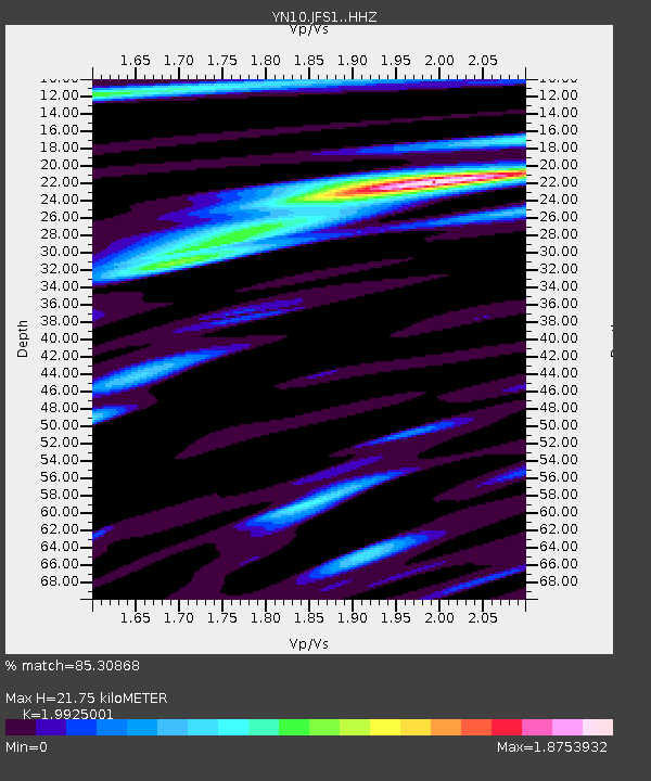
JFS1 JFS1 - Earthquake Result Viewer
| Earthquake location: |
Samoa Islands Region |
| Earthquake latitude/longitude: |
-15.6/-173.0 |
| Earthquake time(UTC): |
2015/06/12 (163) 11:07:04 GMT |
| Earthquake Depth: |
29 km |
| Earthquake Magnitude: |
6.3 MO |
| Earthquake Catalog/Contributor: |
NEIC PDE/NEIC ALERT |
|
| Network: |
YN San Jacinto Fault Zone |
| Station: |
JFS1 JFS1 |
| Lat/Lon: |
33.42 N/116.40 W |
| Elevation: |
648 m |
|
| Distance: |
72.7 deg |
| Az: |
46.987 deg |
| Baz: |
237.408 deg |
| Ray Param: |
0.05344468 |
| Estimated Moho Depth: |
21.75 km |
| Estimated Crust Vp/Vs: |
1.99 |
| Assumed Crust Vp: |
6.264 km/s |
| Estimated Crust Vs: |
3.144 km/s |
| Estimated Crust Poisson's Ratio: |
0.33 |
|
| Radial Match: |
85.30868 % |
| Radial Bump: |
400 |
| Transverse Match: |
83.56632 % |
| Transverse Bump: |
400 |
| SOD ConfigId: |
7422571 |
| Insert Time: |
2019-04-19 08:01:28.812 +0000 |
| GWidth: |
2.5 |
| Max Bumps: |
400 |
| Tol: |
0.001 |
|

Signal To Noise
| Channel | StoN | STA | LTA |
| YN:JFS1: :HHZ:20150612T11:17:59.314001Z | 11.699105 | 1.0686257E-6 | 9.1342514E-8 |
| YN:JFS1: :HHN:20150612T11:17:59.314001Z | 1.3220583 | 1.362669E-7 | 1.0307178E-7 |
| YN:JFS1: :HHE:20150612T11:17:59.314001Z | 2.4070992 | 3.1730883E-7 | 1.3182208E-7 |
| Arrivals |
| Ps | 3.5 SECOND |
| PpPs | 10 SECOND |
| PsPs/PpSs | 14 SECOND |


