You are here: Home > Network List > IU - Global Seismograph Network (GSN - IRIS/USGS) Stations List
> Station CTAO Charters Towers, Australia > Earthquake Result Viewer
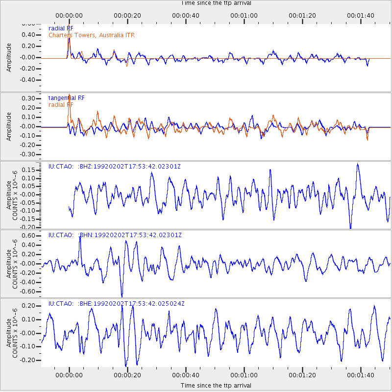
CTAO Charters Towers, Australia - Earthquake Result Viewer
*The percent match for this event was below the threshold and hence no stack was calculated.
| Earthquake location: |
Kuril Islands |
| Earthquake latitude/longitude: |
45.3/150.8 |
| Earthquake time(UTC): |
1992/02/02 (033) 17:43:35 GMT |
| Earthquake Depth: |
36 km |
| Earthquake Magnitude: |
5.5 MB, 5.6 MS |
| Earthquake Catalog/Contributor: |
WHDF/NEIC |
|
| Network: |
IU Global Seismograph Network (GSN - IRIS/USGS) |
| Station: |
CTAO Charters Towers, Australia |
| Lat/Lon: |
20.09 S/146.25 E |
| Elevation: |
357 m |
|
| Distance: |
65.2 deg |
| Az: |
184.71 deg |
| Baz: |
3.533 deg |
| Ray Param: |
$rayparam |
*The percent match for this event was below the threshold and hence was not used in the summary stack. |
|
| Radial Match: |
65.36334 % |
| Radial Bump: |
400 |
| Transverse Match: |
63.855743 % |
| Transverse Bump: |
400 |
| SOD ConfigId: |
4480 |
| Insert Time: |
2010-03-03 14:37:21.412 +0000 |
| GWidth: |
2.5 |
| Max Bumps: |
400 |
| Tol: |
0.001 |
|
Signal To Noise
| Channel | StoN | STA | LTA |
| IU:CTAO: :BHN:19920202T17:53:42.02301Z | 2.4664164 | 1.8750366E-7 | 7.6022715E-8 |
| IU:CTAO: :BHE:19920202T17:53:42.025024Z | 1.0081061 | 5.974638E-8 | 5.9265965E-8 |
| IU:CTAO: :BHZ:19920202T17:53:42.02301Z | 1.5161268 | 7.592729E-8 | 5.0079777E-8 |
| Arrivals |
| Ps | |
| PpPs | |
| PsPs/PpSs | |


