You are here: Home > Network List > IU - Global Seismograph Network (GSN - IRIS/USGS) Stations List
> Station CTAO Charters Towers, Australia > Earthquake Result Viewer
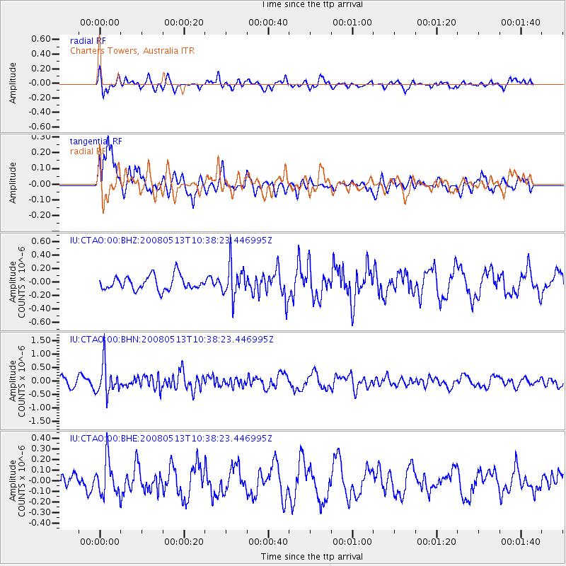
CTAO Charters Towers, Australia - Earthquake Result Viewer
*The percent match for this event was below the threshold and hence no stack was calculated.
| Earthquake location: |
Northern Sumatra, Indonesia |
| Earthquake latitude/longitude: |
4.7/95.1 |
| Earthquake time(UTC): |
2008/05/13 (134) 10:29:19 GMT |
| Earthquake Depth: |
35 km |
| Earthquake Magnitude: |
5.6 MB, 5.1 MS, 5.4 MW, 5.4 MW |
| Earthquake Catalog/Contributor: |
WHDF/NEIC |
|
| Network: |
IU Global Seismograph Network (GSN - IRIS/USGS) |
| Station: |
CTAO Charters Towers, Australia |
| Lat/Lon: |
20.09 S/146.25 E |
| Elevation: |
357 m |
|
| Distance: |
56.0 deg |
| Az: |
117.924 deg |
| Baz: |
290.45 deg |
| Ray Param: |
$rayparam |
*The percent match for this event was below the threshold and hence was not used in the summary stack. |
|
| Radial Match: |
45.66116 % |
| Radial Bump: |
400 |
| Transverse Match: |
73.27026 % |
| Transverse Bump: |
400 |
| SOD ConfigId: |
2504 |
| Insert Time: |
2010-03-03 14:37:26.236 +0000 |
| GWidth: |
2.5 |
| Max Bumps: |
400 |
| Tol: |
0.001 |
|
Signal To Noise
| Channel | StoN | STA | LTA |
| IU:CTAO:00:BHN:20080513T10:38:23.446995Z | 3.9198558 | 5.665918E-7 | 1.4454403E-7 |
| IU:CTAO:00:BHE:20080513T10:38:23.446995Z | 1.9105525 | 1.7096798E-7 | 8.948614E-8 |
| IU:CTAO:00:BHZ:20080513T10:38:23.446995Z | 2.3212614 | 2.420541E-7 | 1.0427698E-7 |
| Arrivals |
| Ps | |
| PpPs | |
| PsPs/PpSs | |


