You are here: Home > Network List > IU - Global Seismograph Network (GSN - IRIS/USGS) Stations List
> Station CTAO Charters Towers, Australia > Earthquake Result Viewer
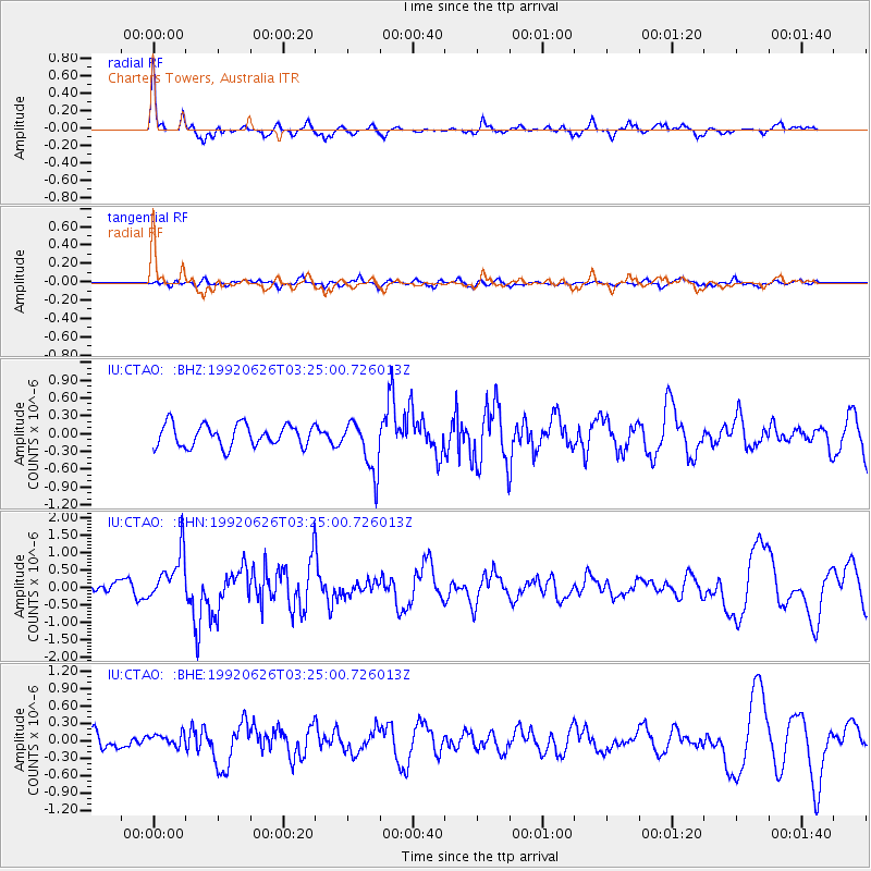
CTAO Charters Towers, Australia - Earthquake Result Viewer
*The percent match for this event was below the threshold and hence no stack was calculated.
| Earthquake location: |
South Of Kermadec Islands |
| Earthquake latitude/longitude: |
-33.7/-179.1 |
| Earthquake time(UTC): |
1992/06/26 (178) 03:18:54 GMT |
| Earthquake Depth: |
33 km |
| Earthquake Magnitude: |
5.6 MB, 5.7 MS |
| Earthquake Catalog/Contributor: |
WHDF/NEIC |
|
| Network: |
IU Global Seismograph Network (GSN - IRIS/USGS) |
| Station: |
CTAO Charters Towers, Australia |
| Lat/Lon: |
20.09 S/146.25 E |
| Elevation: |
357 m |
|
| Distance: |
33.6 deg |
| Az: |
284.875 deg |
| Baz: |
120.971 deg |
| Ray Param: |
$rayparam |
*The percent match for this event was below the threshold and hence was not used in the summary stack. |
|
| Radial Match: |
73.80407 % |
| Radial Bump: |
251 |
| Transverse Match: |
39.686733 % |
| Transverse Bump: |
369 |
| SOD ConfigId: |
4480 |
| Insert Time: |
2010-03-03 14:37:34.475 +0000 |
| GWidth: |
2.5 |
| Max Bumps: |
400 |
| Tol: |
0.001 |
|
Signal To Noise
| Channel | StoN | STA | LTA |
| IU:CTAO: :BHN:19920626T03:25:00.726013Z | 2.5056903 | 6.872512E-7 | 2.742762E-7 |
| IU:CTAO: :BHE:19920626T03:25:00.726013Z | 0.5785069 | 1.00811036E-7 | 1.7426073E-7 |
| IU:CTAO: :BHZ:19920626T03:25:00.726013Z | 2.3725832 | 4.3827373E-7 | 1.8472429E-7 |
| Arrivals |
| Ps | |
| PpPs | |
| PsPs/PpSs | |


