You are here: Home > Network List > IU - Global Seismograph Network (GSN - IRIS/USGS) Stations List
> Station CTAO Charters Towers, Australia > Earthquake Result Viewer
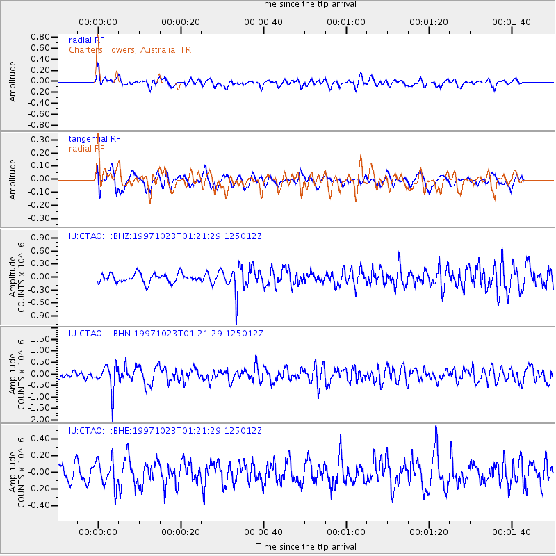
CTAO Charters Towers, Australia - Earthquake Result Viewer
*The percent match for this event was below the threshold and hence no stack was calculated.
| Earthquake location: |
Sumbawa Region, Indonesia |
| Earthquake latitude/longitude: |
-8.7/117.0 |
| Earthquake time(UTC): |
1997/10/23 (296) 01:16:01 GMT |
| Earthquake Depth: |
160 km |
| Earthquake Magnitude: |
5.5 MB |
| Earthquake Catalog/Contributor: |
WHDF/NEIC |
|
| Network: |
IU Global Seismograph Network (GSN - IRIS/USGS) |
| Station: |
CTAO Charters Towers, Australia |
| Lat/Lon: |
20.09 S/146.25 E |
| Elevation: |
357 m |
|
| Distance: |
30.5 deg |
| Az: |
115.077 deg |
| Baz: |
287.675 deg |
| Ray Param: |
$rayparam |
*The percent match for this event was below the threshold and hence was not used in the summary stack. |
|
| Radial Match: |
63.98266 % |
| Radial Bump: |
400 |
| Transverse Match: |
57.006695 % |
| Transverse Bump: |
400 |
| SOD ConfigId: |
4480 |
| Insert Time: |
2010-03-03 14:37:37.724 +0000 |
| GWidth: |
2.5 |
| Max Bumps: |
400 |
| Tol: |
0.001 |
|
Signal To Noise
| Channel | StoN | STA | LTA |
| IU:CTAO: :BHN:19971023T01:21:29.125012Z | 3.3727584 | 5.732406E-7 | 1.6996195E-7 |
| IU:CTAO: :BHE:19971023T01:21:29.125012Z | 1.2222042 | 1.5616645E-7 | 1.2777444E-7 |
| IU:CTAO: :BHZ:19971023T01:21:29.125012Z | 2.982516 | 3.0250015E-7 | 1.0142448E-7 |
| Arrivals |
| Ps | |
| PpPs | |
| PsPs/PpSs | |


