You are here: Home > Network List > IU - Global Seismograph Network (GSN - IRIS/USGS) Stations List
> Station CTAO Charters Towers, Australia > Earthquake Result Viewer
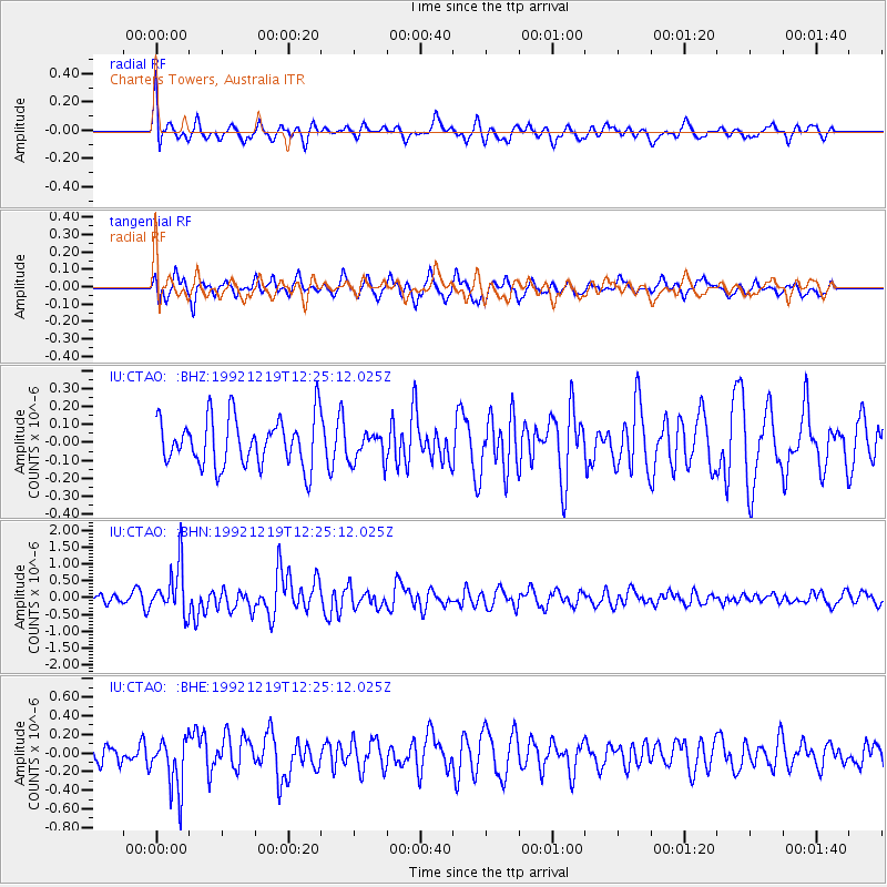
CTAO Charters Towers, Australia - Earthquake Result Viewer
*The percent match for this event was below the threshold and hence no stack was calculated.
| Earthquake location: |
Near East Coast Of Kamchatka |
| Earthquake latitude/longitude: |
51.9/158.5 |
| Earthquake time(UTC): |
1992/12/19 (354) 12:14:22 GMT |
| Earthquake Depth: |
56 km |
| Earthquake Magnitude: |
6.1 MB |
| Earthquake Catalog/Contributor: |
WHDF/NEIC |
|
| Network: |
IU Global Seismograph Network (GSN - IRIS/USGS) |
| Station: |
CTAO Charters Towers, Australia |
| Lat/Lon: |
20.09 S/146.25 E |
| Elevation: |
357 m |
|
| Distance: |
72.5 deg |
| Az: |
192.079 deg |
| Baz: |
7.933 deg |
| Ray Param: |
$rayparam |
*The percent match for this event was below the threshold and hence was not used in the summary stack. |
|
| Radial Match: |
64.11724 % |
| Radial Bump: |
400 |
| Transverse Match: |
66.81191 % |
| Transverse Bump: |
400 |
| SOD ConfigId: |
4480 |
| Insert Time: |
2010-03-03 14:37:44.277 +0000 |
| GWidth: |
2.5 |
| Max Bumps: |
400 |
| Tol: |
0.001 |
|
Signal To Noise
| Channel | StoN | STA | LTA |
| IU:CTAO: :BHN:19921219T12:25:12.025Z | 4.36936 | 7.155709E-7 | 1.6377018E-7 |
| IU:CTAO: :BHE:19921219T12:25:12.025Z | 2.0345259 | 2.7870394E-7 | 1.3698717E-7 |
| IU:CTAO: :BHZ:19921219T12:25:12.025Z | 0.62521875 | 8.427575E-8 | 1.34794E-7 |
| Arrivals |
| Ps | |
| PpPs | |
| PsPs/PpSs | |


