You are here: Home > Network List > AV - Alaska Volcano Observatory Stations List
> Station SPCR Ckakachatna River, Mount Spurr, Alaska > Earthquake Result Viewer
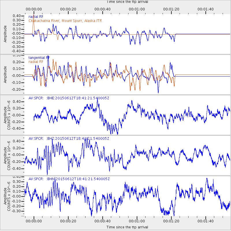
SPCR Ckakachatna River, Mount Spurr, Alaska - Earthquake Result Viewer
*The percent match for this event was below the threshold and hence no stack was calculated.
| Earthquake location: |
Borneo |
| Earthquake latitude/longitude: |
6.1/116.6 |
| Earthquake time(UTC): |
2015/06/12 (163) 18:29:18 GMT |
| Earthquake Depth: |
28 km |
| Earthquake Magnitude: |
5.2 MW |
| Earthquake Catalog/Contributor: |
ISC/ISC |
|
| Network: |
AV Alaska Volcano Observatory |
| Station: |
SPCR Ckakachatna River, Mount Spurr, Alaska |
| Lat/Lon: |
61.20 N/152.21 W |
| Elevation: |
984 m |
|
| Distance: |
85.3 deg |
| Az: |
29.063 deg |
| Baz: |
273.947 deg |
| Ray Param: |
$rayparam |
*The percent match for this event was below the threshold and hence was not used in the summary stack. |
|
| Radial Match: |
54.716244 % |
| Radial Bump: |
400 |
| Transverse Match: |
38.552193 % |
| Transverse Bump: |
400 |
| SOD ConfigId: |
7422571 |
| Insert Time: |
2019-04-19 08:08:58.556 +0000 |
| GWidth: |
2.5 |
| Max Bumps: |
400 |
| Tol: |
0.001 |
|
Signal To Noise
| Channel | StoN | STA | LTA |
| AV:SPCR: :BHZ:20150612T18:41:21.540005Z | 1.307157 | 2.29594E-7 | 1.7564378E-7 |
| AV:SPCR: :BHN:20150612T18:41:21.540005Z | 1.0530262 | 9.928893E-8 | 9.4289135E-8 |
| AV:SPCR: :BHE:20150612T18:41:21.540005Z | 2.4205472 | 2.5092882E-7 | 1.0366615E-7 |
| Arrivals |
| Ps | |
| PpPs | |
| PsPs/PpSs | |


