GUMO Guam, Marianas Islands - Earthquake Result Viewer
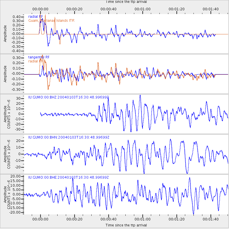
Earthquake location: Southeast Of Loyalty Islands
Earthquake latitude/longitude: -22.3/169.7
Earthquake time(UTC): 2004/01/03 (003) 16:23:21 GMT
Earthquake Depth: 22 km
Earthquake Magnitude: 6.4 MB, 7.1 MS, 7.1 MW, 6.8 MW
Earthquake Catalog/Contributor: WHDF/NEIC
Network: IU Global Seismograph Network (GSN - IRIS/USGS)
Station: GUMO Guam, Marianas Islands
Lat/Lon: 13.59 N/144.87 E
Elevation: 14 m
Distance: 43.1 deg
Az: 323.352 deg
Baz: 145.342 deg
Ray Param: 0.07271294
Estimated Moho Depth: 54.5 km
Estimated Crust Vp/Vs: 2.09
Assumed Crust Vp: 4.802 km/s
Estimated Crust Vs: 2.303 km/s
Estimated Crust Poisson's Ratio: 0.35
Radial Match: 85.620316 %
Radial Bump: 400
Transverse Match: 75.26821 %
Transverse Bump: 400
SOD ConfigId: 7314
Insert Time: 2010-03-03 14:38:11.167 +0000
GWidth: 2.5
Max Bumps: 400
Tol: 0.001

Signal To Noise

ChannelStoNSTALTA
IU:GUMO:00:BHN:20040103T16:30:48.99699Z1.66319472.451149E-61.4737595E-6
IU:GUMO:00:BHE:20040103T16:30:48.99699Z1.11689531.8081952E-61.6189479E-6
IU:GUMO:00:BHZ:20040103T16:30:48.99699Z5.28653676.8755407E-61.3005756E-6
Arrivals
Ps13 SECOND
PpPs34 SECOND
PsPs/PpSs47 SECOND