You are here: Home > Network List > IU - Global Seismograph Network (GSN - IRIS/USGS) Stations List
> Station GUMO Guam, Marianas Islands > Earthquake Result Viewer
GUMO Guam, Marianas Islands - Earthquake Result Viewer
| Earthquake location: |
Tonga Islands |
| Earthquake latitude/longitude: |
-16.8/-174.2 |
| Earthquake time(UTC): |
2004/01/25 (025) 11:43:11 GMT |
| Earthquake Depth: |
130 km |
| Earthquake Magnitude: |
6.4 MB, 6.7 MW, 6.7 MW |
| Earthquake Catalog/Contributor: |
WHDF/NEIC |
|
| Network: |
IU Global Seismograph Network (GSN - IRIS/USGS) |
| Station: |
GUMO Guam, Marianas Islands |
| Lat/Lon: |
13.59 N/144.87 E |
| Elevation: |
14 m |
|
| Distance: |
50.5 deg |
| Az: |
304.32 deg |
| Baz: |
125.566 deg |
| Ray Param: |
0.06758877 |
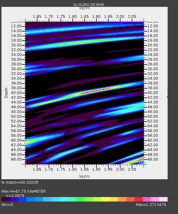
| Estimated Moho Depth: |
67.75 km |
| Estimated Crust Vp/Vs: |
2.10 |
| Assumed Crust Vp: |
4.802 km/s |
| Estimated Crust Vs: |
2.289 km/s |
| Estimated Crust Poisson's Ratio: |
0.35 |
|
| Radial Match: |
80.32839 % |
| Radial Bump: |
400 |
| Transverse Match: |
74.37764 % |
| Transverse Bump: |
378 |
| SOD ConfigId: |
2459 |
| Insert Time: |
2010-03-03 14:38:15.540 +0000 |
| GWidth: |
2.5 |
| Max Bumps: |
400 |
| Tol: |
0.001 |
|
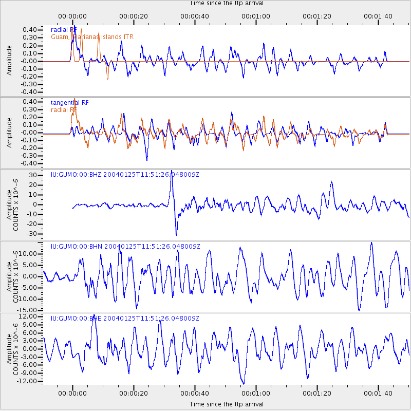
Signal To Noise
| Channel | StoN | STA | LTA |
| IU:GUMO:00:BHN:20040125T11:51:26.048009Z | 2.034731 | 4.039414E-6 | 1.9852325E-6 |
| IU:GUMO:00:BHE:20040125T11:51:26.048009Z | 2.054942 | 3.846953E-6 | 1.8720494E-6 |
| IU:GUMO:00:BHZ:20040125T11:51:26.048009Z | 12.087556 | 1.5484617E-5 | 1.2810378E-6 |
| Arrivals |
| Ps | 16 SECOND |
| PpPs | 43 SECOND |
| PsPs/PpSs | 58 SECOND |


