You are here: Home > Network List > IU - Global Seismograph Network (GSN - IRIS/USGS) Stations List
> Station GUMO Guam, Marianas Islands > Earthquake Result Viewer
GUMO Guam, Marianas Islands - Earthquake Result Viewer

| Earthquake location: |
Kermadec Islands Region |
| Earthquake latitude/longitude: |
-31.5/-178.8 |
| Earthquake time(UTC): |
2009/05/16 (136) 00:53:52 GMT |
| Earthquake Depth: |
55 km |
| Earthquake Magnitude: |
6.1 MB, 6.5 MW, 6.3 MW |
| Earthquake Catalog/Contributor: |
WHDF/NEIC |
|
| Network: |
IU Global Seismograph Network (GSN - IRIS/USGS) |
| Station: |
GUMO Guam, Marianas Islands |
| Lat/Lon: |
13.59 N/144.87 E |
| Elevation: |
14 m |
|
| Distance: |
56.8 deg |
| Az: |
316.482 deg |
| Baz: |
142.787 deg |
| Ray Param: |
0.06376541 |
| Estimated Moho Depth: |
12.25 km |
| Estimated Crust Vp/Vs: |
1.87 |
| Assumed Crust Vp: |
4.802 km/s |
| Estimated Crust Vs: |
2.568 km/s |
| Estimated Crust Poisson's Ratio: |
0.30 |
|
| Radial Match: |
85.30148 % |
| Radial Bump: |
400 |
| Transverse Match: |
76.461395 % |
| Transverse Bump: |
400 |
| SOD ConfigId: |
2760 |
| Insert Time: |
2010-03-03 14:38:16.942 +0000 |
| GWidth: |
2.5 |
| Max Bumps: |
400 |
| Tol: |
0.001 |
|
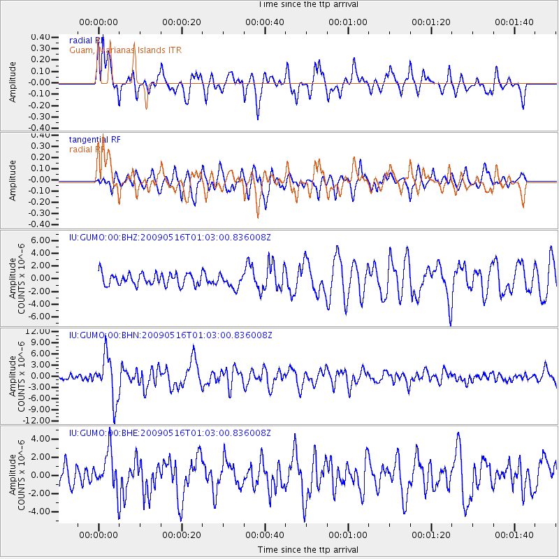
Signal To Noise
| Channel | StoN | STA | LTA |
| IU:GUMO:00:BHN:20090516T01:03:00.836008Z | 7.754632 | 6.0973134E-6 | 7.8628017E-7 |
| IU:GUMO:00:BHE:20090516T01:03:00.836008Z | 2.3787916 | 2.2294344E-6 | 9.37213E-7 |
| IU:GUMO:00:BHZ:20090516T01:03:00.836008Z | 1.1962909 | 1.0875037E-6 | 9.09063E-7 |
| Arrivals |
| Ps | 2.3 SECOND |
| PpPs | 7.1 SECOND |
| PsPs/PpSs | 9.4 SECOND |


