You are here: Home > Network List > WY - Yellowstone Wyoming Seismic Network Stations List
> Station YHH Holmes Hill, YNP, WY, USA > Earthquake Result Viewer
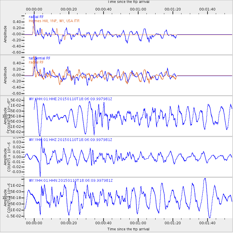
YHH Holmes Hill, YNP, WY, USA - Earthquake Result Viewer
*The percent match for this event was below the threshold and hence no stack was calculated.
| Earthquake location: |
Chile-Bolivia Border Region |
| Earthquake latitude/longitude: |
-21.6/-68.5 |
| Earthquake time(UTC): |
2015/01/10 (010) 17:55:02 GMT |
| Earthquake Depth: |
109 km |
| Earthquake Magnitude: |
5.5 MWW, 5.4 MWR, 5.5 MWB |
| Earthquake Catalog/Contributor: |
NEIC PDE/NEIC COMCAT |
|
| Network: |
WY Yellowstone Wyoming Seismic Network |
| Station: |
YHH Holmes Hill, YNP, WY, USA |
| Lat/Lon: |
44.79 N/110.85 W |
| Elevation: |
2717 m |
|
| Distance: |
76.6 deg |
| Az: |
330.468 deg |
| Baz: |
139.907 deg |
| Ray Param: |
$rayparam |
*The percent match for this event was below the threshold and hence was not used in the summary stack. |
|
| Radial Match: |
64.23083 % |
| Radial Bump: |
400 |
| Transverse Match: |
63.7265 % |
| Transverse Bump: |
400 |
| SOD ConfigId: |
837871 |
| Insert Time: |
2015-02-12 22:07:08.840 +0000 |
| GWidth: |
2.5 |
| Max Bumps: |
400 |
| Tol: |
0.001 |
|
Signal To Noise
| Channel | StoN | STA | LTA |
| WY:YHH:01:HHZ:20150110T18:06:09.997981Z | 3.3975458 | 1.573545E-8 | 4.6314166E-9 |
| WY:YHH:01:HHN:20150110T18:06:09.997981Z | 0.7197414 | 5.147205E-9 | 7.1514643E-9 |
| WY:YHH:01:HHE:20150110T18:06:09.997981Z | 1.6647075 | 1.1310455E-8 | 6.794259E-9 |
| Arrivals |
| Ps | |
| PpPs | |
| PsPs/PpSs | |


