You are here: Home > Network List > IU - Global Seismograph Network (GSN - IRIS/USGS) Stations List
> Station GUMO Guam, Marianas Islands > Earthquake Result Viewer
GUMO Guam, Marianas Islands - Earthquake Result Viewer
| Earthquake location: |
Southeast Of Loyalty Islands |
| Earthquake latitude/longitude: |
-22.0/170.6 |
| Earthquake time(UTC): |
2005/04/11 (101) 17:08:53 GMT |
| Earthquake Depth: |
68 km |
| Earthquake Magnitude: |
6.0 MB, 6.8 MW, 6.8 MW |
| Earthquake Catalog/Contributor: |
WHDF/NEIC |
|
| Network: |
IU Global Seismograph Network (GSN - IRIS/USGS) |
| Station: |
GUMO Guam, Marianas Islands |
| Lat/Lon: |
13.59 N/144.87 E |
| Elevation: |
14 m |
|
| Distance: |
43.4 deg |
| Az: |
322.099 deg |
| Baz: |
144.098 deg |
| Ray Param: |
0.072337046 |
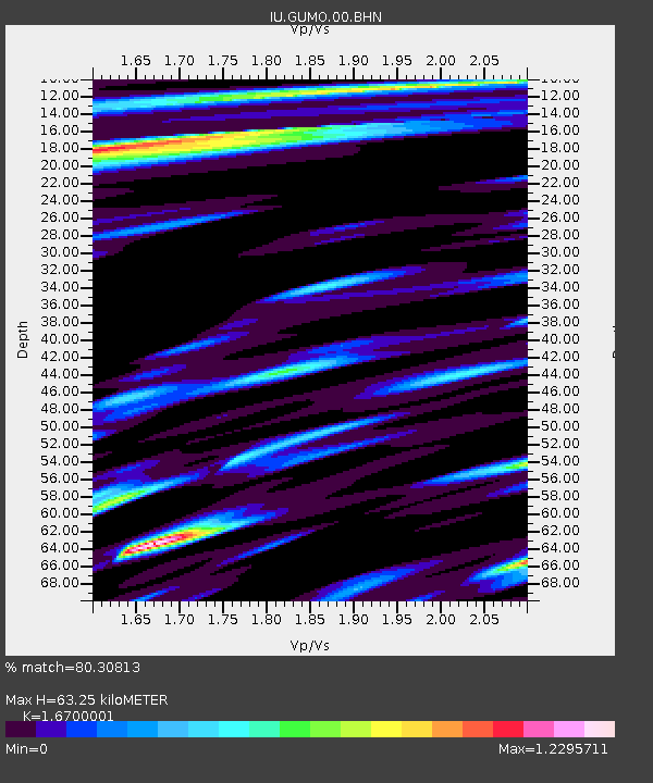
| Estimated Moho Depth: |
63.25 km |
| Estimated Crust Vp/Vs: |
1.67 |
| Assumed Crust Vp: |
4.802 km/s |
| Estimated Crust Vs: |
2.875 km/s |
| Estimated Crust Poisson's Ratio: |
0.22 |
|
| Radial Match: |
80.30813 % |
| Radial Bump: |
312 |
| Transverse Match: |
62.337475 % |
| Transverse Bump: |
385 |
| SOD ConfigId: |
2459 |
| Insert Time: |
2010-03-03 14:38:21.295 +0000 |
| GWidth: |
2.5 |
| Max Bumps: |
400 |
| Tol: |
0.001 |
|

Signal To Noise
| Channel | StoN | STA | LTA |
| IU:GUMO:00:BHN:20050411T17:16:19.70001Z | 6.9356833 | 5.6195067E-6 | 8.102312E-7 |
| IU:GUMO:00:BHE:20050411T17:16:19.70001Z | 3.6546233 | 3.9171464E-6 | 1.0718331E-6 |
| IU:GUMO:00:BHZ:20050411T17:16:19.70001Z | 20.27833 | 1.9511484E-5 | 9.62184E-7 |
| Arrivals |
| Ps | 9.2 SECOND |
| PpPs | 34 SECOND |
| PsPs/PpSs | 43 SECOND |


