You are here: Home > Network List > CI - Caltech Regional Seismic Network Stations List
> Station SWS Sam W. Stewart, Westmorland, CA, USA > Earthquake Result Viewer
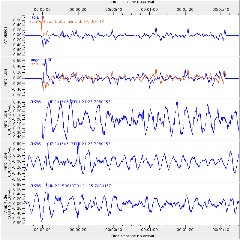
SWS Sam W. Stewart, Westmorland, CA, USA - Earthquake Result Viewer
*The percent match for this event was below the threshold and hence no stack was calculated.
| Earthquake location: |
Alaska Peninsula |
| Earthquake latitude/longitude: |
56.6/-156.6 |
| Earthquake time(UTC): |
2015/06/13 (164) 01:14:56 GMT |
| Earthquake Depth: |
68 km |
| Earthquake Magnitude: |
4.9 MW |
| Earthquake Catalog/Contributor: |
ISC/ISC |
|
| Network: |
CI Caltech Regional Seismic Network |
| Station: |
SWS Sam W. Stewart, Westmorland, CA, USA |
| Lat/Lon: |
32.94 N/115.80 W |
| Elevation: |
140 m |
|
| Distance: |
36.6 deg |
| Az: |
112.829 deg |
| Baz: |
322.73 deg |
| Ray Param: |
$rayparam |
*The percent match for this event was below the threshold and hence was not used in the summary stack. |
|
| Radial Match: |
60.300354 % |
| Radial Bump: |
400 |
| Transverse Match: |
59.685574 % |
| Transverse Bump: |
400 |
| SOD ConfigId: |
7422571 |
| Insert Time: |
2019-04-19 08:16:34.959 +0000 |
| GWidth: |
2.5 |
| Max Bumps: |
400 |
| Tol: |
0.001 |
|
Signal To Noise
| Channel | StoN | STA | LTA |
| CI:SWS: :HHZ:20150613T01:21:25.708015Z | 1.2756934 | 2.463681E-7 | 1.9312486E-7 |
| CI:SWS: :HHN:20150613T01:21:25.708015Z | 1.8599193 | 4.8034093E-7 | 2.58259E-7 |
| CI:SWS: :HHE:20150613T01:21:25.708015Z | 1.0411508 | 2.4021196E-7 | 2.3071773E-7 |
| Arrivals |
| Ps | |
| PpPs | |
| PsPs/PpSs | |


