You are here: Home > Network List > IU - Global Seismograph Network (GSN - IRIS/USGS) Stations List
> Station GUMO Guam, Marianas Islands > Earthquake Result Viewer
GUMO Guam, Marianas Islands - Earthquake Result Viewer
| Earthquake location: |
Tonga Islands |
| Earthquake latitude/longitude: |
-21.9/-173.8 |
| Earthquake time(UTC): |
2008/10/19 (293) 05:10:33 GMT |
| Earthquake Depth: |
29 km |
| Earthquake Magnitude: |
6.8 MB, 7.0 MS, 6.9 MW, 6.9 MW |
| Earthquake Catalog/Contributor: |
WHDF/NEIC |
|
| Network: |
IU Global Seismograph Network (GSN - IRIS/USGS) |
| Station: |
GUMO Guam, Marianas Islands |
| Lat/Lon: |
13.59 N/144.87 E |
| Elevation: |
14 m |
|
| Distance: |
53.7 deg |
| Az: |
307.199 deg |
| Baz: |
130.451 deg |
| Ray Param: |
0.0658731 |
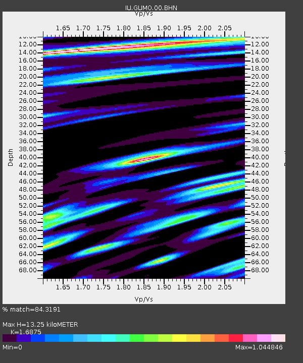
| Estimated Moho Depth: |
13.25 km |
| Estimated Crust Vp/Vs: |
1.69 |
| Assumed Crust Vp: |
4.802 km/s |
| Estimated Crust Vs: |
2.846 km/s |
| Estimated Crust Poisson's Ratio: |
0.23 |
|
| Radial Match: |
84.3191 % |
| Radial Bump: |
400 |
| Transverse Match: |
78.7831 % |
| Transverse Bump: |
400 |
| SOD ConfigId: |
2556 |
| Insert Time: |
2010-03-03 14:38:29.429 +0000 |
| GWidth: |
2.5 |
| Max Bumps: |
400 |
| Tol: |
0.001 |
|

Signal To Noise
| Channel | StoN | STA | LTA |
| IU:GUMO:00:BHN:20081019T05:19:22.336025Z | 35.079266 | 1.3628178E-5 | 3.884967E-7 |
| IU:GUMO:00:BHE:20081019T05:19:22.336025Z | 10.742626 | 4.2737065E-6 | 3.9782697E-7 |
| IU:GUMO:00:BHZ:20081019T05:19:22.336025Z | 4.276539 | 2.71488E-6 | 6.3483117E-7 |
| Arrivals |
| Ps | 2.0 SECOND |
| PpPs | 7.2 SECOND |
| PsPs/PpSs | 9.1 SECOND |


