You are here: Home > Network List > IU - Global Seismograph Network (GSN - IRIS/USGS) Stations List
> Station GUMO Guam, Marianas Islands > Earthquake Result Viewer
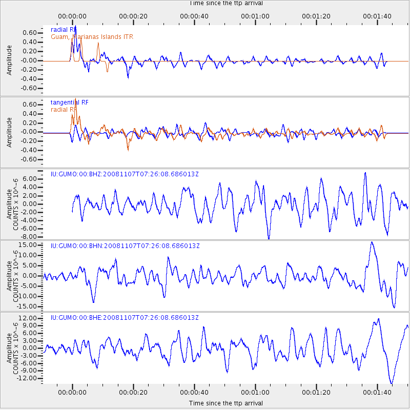
GUMO Guam, Marianas Islands - Earthquake Result Viewer

| Earthquake location: |
Vanuatu Islands |
| Earthquake latitude/longitude: |
-14.8/168.0 |
| Earthquake time(UTC): |
2008/11/07 (312) 07:19:35 GMT |
| Earthquake Depth: |
13 km |
| Earthquake Magnitude: |
6.0 MB, 6.3 MS, 6.4 MW, 6.4 MW |
| Earthquake Catalog/Contributor: |
WHDF/NEIC |
|
| Network: |
IU Global Seismograph Network (GSN - IRIS/USGS) |
| Station: |
GUMO Guam, Marianas Islands |
| Lat/Lon: |
13.59 N/144.87 E |
| Elevation: |
14 m |
|
| Distance: |
36.4 deg |
| Az: |
319.83 deg |
| Baz: |
140.091 deg |
| Ray Param: |
0.07670996 |
| Estimated Moho Depth: |
10.0 km |
| Estimated Crust Vp/Vs: |
2.07 |
| Assumed Crust Vp: |
4.802 km/s |
| Estimated Crust Vs: |
2.323 km/s |
| Estimated Crust Poisson's Ratio: |
0.35 |
|
| Radial Match: |
88.21427 % |
| Radial Bump: |
343 |
| Transverse Match: |
60.633766 % |
| Transverse Bump: |
400 |
| SOD ConfigId: |
2658 |
| Insert Time: |
2010-03-03 14:38:32.294 +0000 |
| GWidth: |
2.5 |
| Max Bumps: |
400 |
| Tol: |
0.001 |
|
Signal To Noise
| Channel | StoN | STA | LTA |
| IU:GUMO:00:BHN:20081107T07:26:08.686013Z | 2.2325313 | 2.5828626E-6 | 1.156921E-6 |
| IU:GUMO:00:BHE:20081107T07:26:08.686013Z | 1.506549 | 1.9259826E-6 | 1.2784068E-6 |
| IU:GUMO:00:BHZ:20081107T07:26:08.686013Z | 1.1496476 | 1.5963718E-6 | 1.388575E-6 |
| Arrivals |
| Ps | 2.3 SECOND |
| PpPs | 6.2 SECOND |
| PsPs/PpSs | 8.5 SECOND |


