You are here: Home > Network List > IU - Global Seismograph Network (GSN - IRIS/USGS) Stations List
> Station GUMO Guam, Marianas Islands > Earthquake Result Viewer
GUMO Guam, Marianas Islands - Earthquake Result Viewer
| Earthquake location: |
South Of Java, Indonesia |
| Earthquake latitude/longitude: |
-10.5/113.0 |
| Earthquake time(UTC): |
1994/06/02 (153) 18:17:36 GMT |
| Earthquake Depth: |
39 km |
| Earthquake Magnitude: |
5.5 MB, 7.2 MS, 6.8 UNKNOWN, 7.7 MW |
| Earthquake Catalog/Contributor: |
WHDF/NEIC |
|
| Network: |
IU Global Seismograph Network (GSN - IRIS/USGS) |
| Station: |
GUMO Guam, Marianas Islands |
| Lat/Lon: |
13.59 N/144.87 E |
| Elevation: |
14 m |
|
| Distance: |
39.7 deg |
| Az: |
53.601 deg |
| Baz: |
234.505 deg |
| Ray Param: |
0.07477042 |
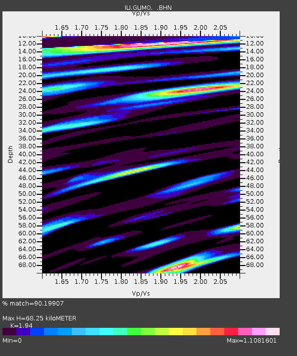
| Estimated Moho Depth: |
68.25 km |
| Estimated Crust Vp/Vs: |
1.94 |
| Assumed Crust Vp: |
4.802 km/s |
| Estimated Crust Vs: |
2.475 km/s |
| Estimated Crust Poisson's Ratio: |
0.32 |
|
| Radial Match: |
90.19907 % |
| Radial Bump: |
400 |
| Transverse Match: |
86.72212 % |
| Transverse Bump: |
400 |
| SOD ConfigId: |
16938 |
| Insert Time: |
2010-03-03 14:38:42.060 +0000 |
| GWidth: |
2.5 |
| Max Bumps: |
400 |
| Tol: |
0.001 |
|

Signal To Noise
| Channel | StoN | STA | LTA |
| IU:GUMO: :BHN:19940602T18:24:34.542004Z | 2.4177806 | 4.8249814E-7 | 1.9956241E-7 |
| IU:GUMO: :BHE:19940602T18:24:34.542004Z | 2.8793018 | 7.749004E-7 | 2.6912787E-7 |
| IU:GUMO: :BHZ:19940602T18:24:34.542004Z | 2.6586707 | 8.5851354E-7 | 3.229108E-7 |
| Arrivals |
| Ps | 14 SECOND |
| PpPs | 40 SECOND |
| PsPs/PpSs | 54 SECOND |


