You are here: Home > Network List > IU - Global Seismograph Network (GSN - IRIS/USGS) Stations List
> Station GUMO Guam, Marianas Islands > Earthquake Result Viewer
GUMO Guam, Marianas Islands - Earthquake Result Viewer
| Earthquake location: |
South Of Java, Indonesia |
| Earthquake latitude/longitude: |
-10.8/113.4 |
| Earthquake time(UTC): |
1994/06/04 (155) 00:57:53 GMT |
| Earthquake Depth: |
33 km |
| Earthquake Magnitude: |
5.8 MB, 6.2 MS, 6.0 UNKNOWN |
| Earthquake Catalog/Contributor: |
WHDF/NEIC |
|
| Network: |
IU Global Seismograph Network (GSN - IRIS/USGS) |
| Station: |
GUMO Guam, Marianas Islands |
| Lat/Lon: |
13.59 N/144.87 E |
| Elevation: |
14 m |
|
| Distance: |
39.5 deg |
| Az: |
52.913 deg |
| Baz: |
233.718 deg |
| Ray Param: |
0.07489232 |
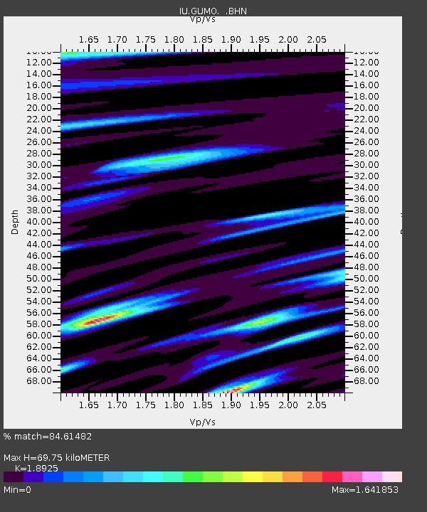
| Estimated Moho Depth: |
69.75 km |
| Estimated Crust Vp/Vs: |
1.89 |
| Assumed Crust Vp: |
4.802 km/s |
| Estimated Crust Vs: |
2.537 km/s |
| Estimated Crust Poisson's Ratio: |
0.31 |
|
| Radial Match: |
84.61482 % |
| Radial Bump: |
400 |
| Transverse Match: |
82.617386 % |
| Transverse Bump: |
400 |
| SOD ConfigId: |
16938 |
| Insert Time: |
2010-03-03 14:38:44.173 +0000 |
| GWidth: |
2.5 |
| Max Bumps: |
400 |
| Tol: |
0.001 |
|

Signal To Noise
| Channel | StoN | STA | LTA |
| IU:GUMO: :BHN:19940604T01:04:50.440002Z | 1.237832 | 7.238744E-7 | 5.8479213E-7 |
| IU:GUMO: :BHE:19940604T01:04:50.390991Z | 1.8921143 | 9.1296397E-7 | 4.825099E-7 |
| IU:GUMO: :BHZ:19940604T01:04:50.390991Z | 3.7762933 | 2.0551183E-6 | 5.4421577E-7 |
| Arrivals |
| Ps | 13 SECOND |
| PpPs | 41 SECOND |
| PsPs/PpSs | 54 SECOND |


