You are here: Home > Network List > IU - Global Seismograph Network (GSN - IRIS/USGS) Stations List
> Station GUMO Guam, Marianas Islands > Earthquake Result Viewer
GUMO Guam, Marianas Islands - Earthquake Result Viewer

| Earthquake location: |
Tonga Islands |
| Earthquake latitude/longitude: |
-15.2/-173.6 |
| Earthquake time(UTC): |
1995/04/07 (097) 22:06:58 GMT |
| Earthquake Depth: |
31 km |
| Earthquake Magnitude: |
6.7 MB, 8.0 MS, 7.5 UNKNOWN, 7.1 MD |
| Earthquake Catalog/Contributor: |
WHDF/NEIC |
|
| Network: |
IU Global Seismograph Network (GSN - IRIS/USGS) |
| Station: |
GUMO Guam, Marianas Islands |
| Lat/Lon: |
13.59 N/144.87 E |
| Elevation: |
14 m |
|
| Distance: |
50.1 deg |
| Az: |
302.757 deg |
| Baz: |
123.379 deg |
| Ray Param: |
0.06824676 |
| Estimated Moho Depth: |
15.25 km |
| Estimated Crust Vp/Vs: |
1.89 |
| Assumed Crust Vp: |
4.802 km/s |
| Estimated Crust Vs: |
2.544 km/s |
| Estimated Crust Poisson's Ratio: |
0.30 |
|
| Radial Match: |
84.15768 % |
| Radial Bump: |
335 |
| Transverse Match: |
78.980156 % |
| Transverse Bump: |
400 |
| SOD ConfigId: |
6273 |
| Insert Time: |
2010-03-03 14:38:58.291 +0000 |
| GWidth: |
2.5 |
| Max Bumps: |
400 |
| Tol: |
0.001 |
|
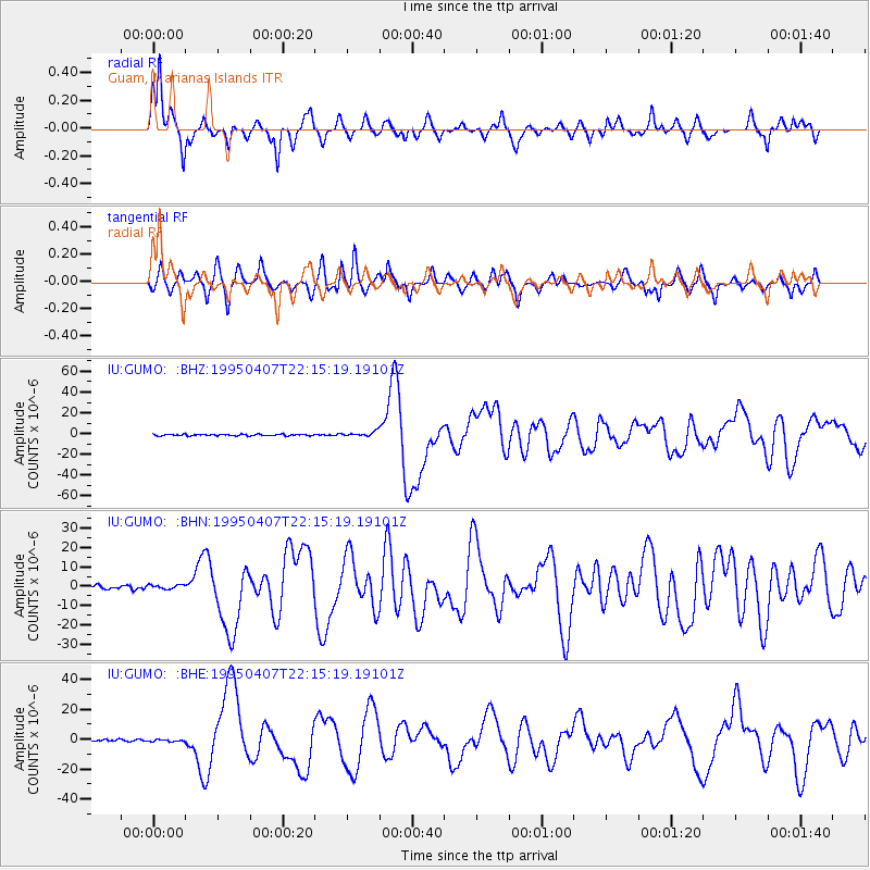
Signal To Noise
| Channel | StoN | STA | LTA |
| IU:GUMO: :BHN:19950407T22:15:19.19101Z | 1.049969 | 1.1280306E-6 | 1.0743465E-6 |
| IU:GUMO: :BHE:19950407T22:15:19.19101Z | 0.7142405 | 7.457337E-7 | 1.0440932E-6 |
| IU:GUMO: :BHZ:19950407T22:15:19.19101Z | 3.2293684 | 2.3467087E-6 | 7.2667734E-7 |
| Arrivals |
| Ps | 2.9 SECOND |
| PpPs | 8.9 SECOND |
| PsPs/PpSs | 12 SECOND |


