You are here: Home > Network List > TA - USArray Transportable Network (new EarthScope stations) Stations List
> Station X43A Marvell, AR, USA > Earthquake Result Viewer
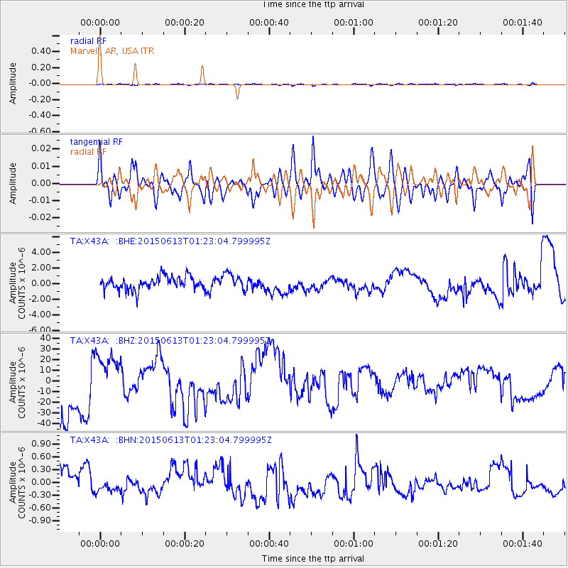
X43A Marvell, AR, USA - Earthquake Result Viewer
*The percent match for this event was below the threshold and hence no stack was calculated.
| Earthquake location: |
Alaska Peninsula |
| Earthquake latitude/longitude: |
56.6/-156.6 |
| Earthquake time(UTC): |
2015/06/13 (164) 01:14:56 GMT |
| Earthquake Depth: |
68 km |
| Earthquake Magnitude: |
4.9 MW |
| Earthquake Catalog/Contributor: |
ISC/ISC |
|
| Network: |
TA USArray Transportable Network (new EarthScope stations) |
| Station: |
X43A Marvell, AR, USA |
| Lat/Lon: |
34.52 N/90.88 W |
| Elevation: |
53 m |
|
| Distance: |
48.9 deg |
| Az: |
87.807 deg |
| Baz: |
318.039 deg |
| Ray Param: |
$rayparam |
*The percent match for this event was below the threshold and hence was not used in the summary stack. |
|
| Radial Match: |
56.65372 % |
| Radial Bump: |
400 |
| Transverse Match: |
64.500275 % |
| Transverse Bump: |
400 |
| SOD ConfigId: |
7422571 |
| Insert Time: |
2019-04-19 08:21:32.278 +0000 |
| GWidth: |
2.5 |
| Max Bumps: |
400 |
| Tol: |
0.001 |
|
Signal To Noise
| Channel | StoN | STA | LTA |
| TA:X43A: :BHZ:20150613T01:23:04.799995Z | 0.7239771 | 1.6713258E-5 | 2.3085342E-5 |
| TA:X43A: :BHN:20150613T01:23:04.799995Z | 0.20163906 | 6.780192E-8 | 3.362539E-7 |
| TA:X43A: :BHE:20150613T01:23:04.799995Z | 1.2679448 | 1.0584034E-6 | 8.347394E-7 |
| Arrivals |
| Ps | |
| PpPs | |
| PsPs/PpSs | |


