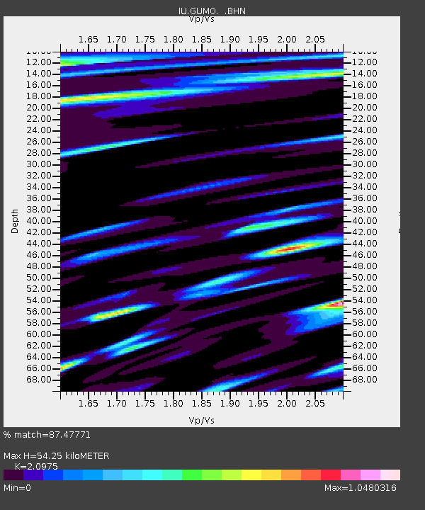
GUMO Guam, Marianas Islands - Earthquake Result Viewer

Earthquake location: Southeast Of Loyalty Islands
Earthquake latitude/longitude: -23.0/170.1
Earthquake time(UTC): 1995/05/17 (137) 11:23:51 GMT
Earthquake Depth: 33 km
Earthquake Magnitude: 5.7 MB, 6.5 MS, 6.5 UNKNOWN, 6.2 MW
Earthquake Catalog/Contributor: WHDF/NEIC
Network: IU Global Seismograph Network (GSN - IRIS/USGS)
Station: GUMO Guam, Marianas Islands
Lat/Lon: 13.59 N/144.87 E
Elevation: 14 m
Distance: 44.0 deg
Az: 323.376 deg
Baz: 145.584 deg
Ray Param: 0.072138034
Estimated Moho Depth: 54.25 km
Estimated Crust Vp/Vs: 2.10
Assumed Crust Vp: 4.802 km/s
Estimated Crust Vs: 2.289 km/s
Estimated Crust Poisson's Ratio: 0.35
Radial Match: 87.47771 %
Radial Bump: 400
Transverse Match: 75.21415 %
Transverse Bump: 400
SOD ConfigId: 6273
Insert Time: 2010-03-03 14:39:01.748 +0000
GWidth: 2.5
Max Bumps: 400
Tol: 0.001

Signal To Noise

ChannelStoNSTALTA
IU:GUMO: :BHN:19950517T11:31:24.640985Z0.724619875.1728915E-77.1387655E-7
IU:GUMO: :BHE:19950517T11:31:24.640985Z1.268936.897586E-75.43575E-7
IU:GUMO: :BHZ:19950517T11:31:24.640985Z2.45370361.6388219E-66.6789727E-7
Arrivals
Ps13 SECOND
PpPs34 SECOND
PsPs/PpSs47 SECOND