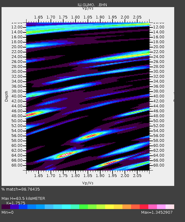
GUMO Guam, Marianas Islands - Earthquake Result Viewer

Earthquake location: Andreanof Islands, Aleutian Is.
Earthquake latitude/longitude: 51.5/-176.8
Earthquake time(UTC): 1996/06/10 (162) 15:24:56 GMT
Earthquake Depth: 26 km
Earthquake Magnitude: 5.9 MB, 7.1 MS, 7.2 UNKNOWN, 6.9 MS
Earthquake Catalog/Contributor: WHDF/NEIC
Network: IU Global Seismograph Network (GSN - IRIS/USGS)
Station: GUMO Guam, Marianas Islands
Lat/Lon: 13.59 N/144.87 E
Elevation: 14 m
Distance: 48.7 deg
Az: 233.269 deg
Baz: 31.028 deg
Ray Param: 0.06911521
Estimated Moho Depth: 63.5 km
Estimated Crust Vp/Vs: 1.76
Assumed Crust Vp: 4.802 km/s
Estimated Crust Vs: 2.732 km/s
Estimated Crust Poisson's Ratio: 0.26
Radial Match: 86.76435 %
Radial Bump: 400
Transverse Match: 83.56071 %
Transverse Bump: 400
SOD ConfigId: 6273
Insert Time: 2010-03-03 14:39:07.547 +0000
GWidth: 2.5
Max Bumps: 400
Tol: 0.001

Signal To Noise

ChannelStoNSTALTA
IU:GUMO: :BHN:19960610T15:33:07.588989Z1.40687841.1116449E-67.9015E-7
IU:GUMO: :BHE:19960610T15:33:07.588989Z1.65290621.2241248E-67.405894E-7
IU:GUMO: :BHZ:19960610T15:33:07.588989Z5.07223032.9689734E-65.853388E-7
Arrivals
Ps10 SECOND
PpPs35 SECOND
PsPs/PpSs46 SECOND