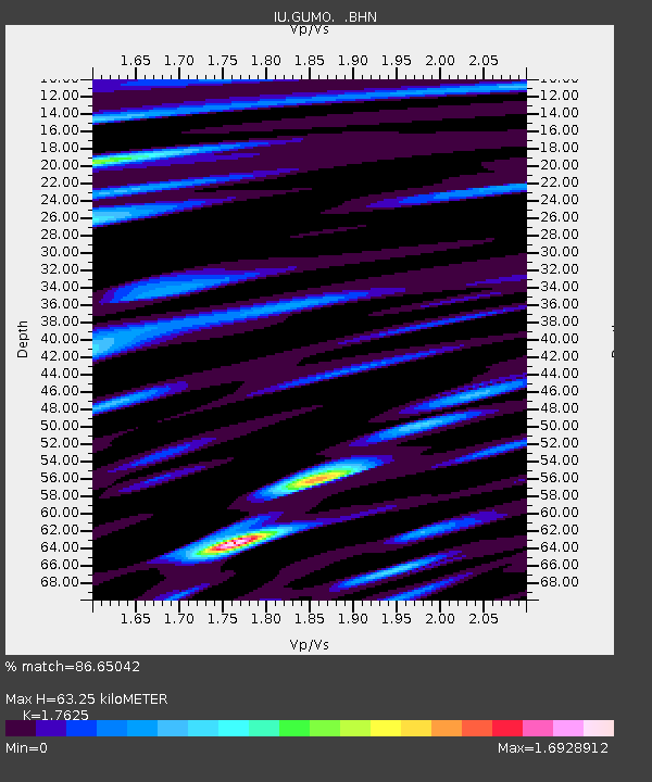
GUMO Guam, Marianas Islands - Earthquake Result Viewer
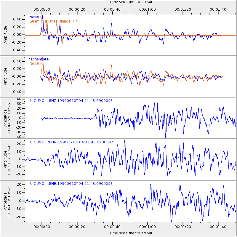
Earthquake location: Andreanof Islands, Aleutian Is.
Earthquake latitude/longitude: 51.6/-177.6
Earthquake time(UTC): 1996/06/10 (162) 04:03:35 GMT
Earthquake Depth: 33 km
Earthquake Magnitude: 6.6 MB, 7.6 MS, 7.9 UNKNOWN, 7.4 MS
Earthquake Catalog/Contributor: WHDF/NEIC
Network: IU Global Seismograph Network (GSN - IRIS/USGS)
Station: GUMO Guam, Marianas Islands
Lat/Lon: 13.59 N/144.87 E
Elevation: 14 m
Distance: 48.4 deg
Az: 232.334 deg
Baz: 30.541 deg
Ray Param: 0.06932008
Estimated Moho Depth: 63.25 km
Estimated Crust Vp/Vs: 1.76
Assumed Crust Vp: 4.802 km/s
Estimated Crust Vs: 2.724 km/s
Estimated Crust Poisson's Ratio: 0.26
Radial Match: 86.65042 %
Radial Bump: 400
Transverse Match: 83.416 %
Transverse Bump: 400
SOD ConfigId: 6273
Insert Time: 2010-03-03 14:39:09.190 +0000
GWidth: 2.5
Max Bumps: 400
Tol: 0.001

Signal To Noise

ChannelStoNSTALTA
IU:GUMO: :BHN:19960610T04:11:43.690009Z4.01031974.398809E-61.0968723E-6
IU:GUMO: :BHE:19960610T04:11:43.690009Z3.67562153.559768E-69.684805E-7
IU:GUMO: :BHZ:19960610T04:11:43.690009Z14.3877811.132944E-57.8743483E-7
Arrivals
Ps10 SECOND
PpPs35 SECOND
PsPs/PpSs46 SECOND