You are here: Home > Network List > IU - Global Seismograph Network (GSN - IRIS/USGS) Stations List
> Station GUMO Guam, Marianas Islands > Earthquake Result Viewer
GUMO Guam, Marianas Islands - Earthquake Result Viewer
| Earthquake location: |
South Of Fiji Islands |
| Earthquake latitude/longitude: |
-24.1/-177.0 |
| Earthquake time(UTC): |
1996/04/16 (107) 00:30:54 GMT |
| Earthquake Depth: |
111 km |
| Earthquake Magnitude: |
6.4 MB, 6.8 MS, 7.1 UNKNOWN, 7.1 MW |
| Earthquake Catalog/Contributor: |
WHDF/NEIC |
|
| Network: |
IU Global Seismograph Network (GSN - IRIS/USGS) |
| Station: |
GUMO Guam, Marianas Islands |
| Lat/Lon: |
13.59 N/144.87 E |
| Elevation: |
14 m |
|
| Distance: |
52.8 deg |
| Az: |
311.114 deg |
| Baz: |
134.906 deg |
| Ray Param: |
0.066175155 |
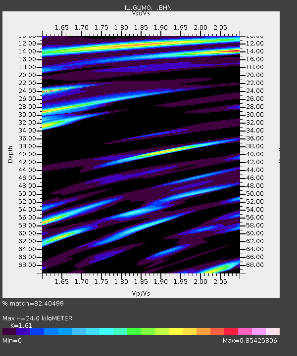
| Estimated Moho Depth: |
24.0 km |
| Estimated Crust Vp/Vs: |
1.61 |
| Assumed Crust Vp: |
4.802 km/s |
| Estimated Crust Vs: |
2.983 km/s |
| Estimated Crust Poisson's Ratio: |
0.19 |
|
| Radial Match: |
82.40499 % |
| Radial Bump: |
400 |
| Transverse Match: |
68.83794 % |
| Transverse Bump: |
400 |
| SOD ConfigId: |
6273 |
| Insert Time: |
2010-03-03 14:39:10.664 +0000 |
| GWidth: |
2.5 |
| Max Bumps: |
400 |
| Tol: |
0.001 |
|

Signal To Noise
| Channel | StoN | STA | LTA |
| IU:GUMO: :BHN:19960416T00:39:27.740015Z | 0.8218156 | 1.2880607E-6 | 1.5673353E-6 |
| IU:GUMO: :BHE:19960416T00:39:27.742029Z | 1.0183035 | 1.2088287E-6 | 1.1871006E-6 |
| IU:GUMO: :BHZ:19960416T00:39:27.742029Z | 5.2825413 | 5.4026013E-6 | 1.0227277E-6 |
| Arrivals |
| Ps | 3.1 SECOND |
| PpPs | 13 SECOND |
| PsPs/PpSs | 16 SECOND |


