You are here: Home > Network List > IU - Global Seismograph Network (GSN - IRIS/USGS) Stations List
> Station GUMO Guam, Marianas Islands > Earthquake Result Viewer
GUMO Guam, Marianas Islands - Earthquake Result Viewer
| Earthquake location: |
Vanuatu Islands |
| Earthquake latitude/longitude: |
-20.4/169.3 |
| Earthquake time(UTC): |
1997/05/21 (141) 14:10:26 GMT |
| Earthquake Depth: |
57 km |
| Earthquake Magnitude: |
5.9 MB, 6.5 MS, 6.7 UNKNOWN, 6.1 ME |
| Earthquake Catalog/Contributor: |
WHDF/NEIC |
|
| Network: |
IU Global Seismograph Network (GSN - IRIS/USGS) |
| Station: |
GUMO Guam, Marianas Islands |
| Lat/Lon: |
13.59 N/144.87 E |
| Elevation: |
14 m |
|
| Distance: |
41.5 deg |
| Az: |
322.625 deg |
| Baz: |
144.164 deg |
| Ray Param: |
0.073602915 |
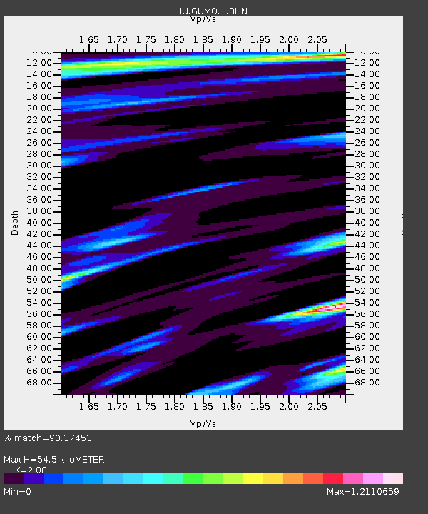
| Estimated Moho Depth: |
54.5 km |
| Estimated Crust Vp/Vs: |
2.08 |
| Assumed Crust Vp: |
4.802 km/s |
| Estimated Crust Vs: |
2.309 km/s |
| Estimated Crust Poisson's Ratio: |
0.35 |
|
| Radial Match: |
90.37453 % |
| Radial Bump: |
400 |
| Transverse Match: |
73.56753 % |
| Transverse Bump: |
400 |
| SOD ConfigId: |
6273 |
| Insert Time: |
2010-03-03 14:39:13.251 +0000 |
| GWidth: |
2.5 |
| Max Bumps: |
400 |
| Tol: |
0.001 |
|

Signal To Noise
| Channel | StoN | STA | LTA |
| IU:GUMO: :BHN:19970521T14:17:37.140002Z | 0.92631507 | 5.146906E-7 | 5.5563237E-7 |
| IU:GUMO: :BHE:19970521T14:17:37.140002Z | 1.8256663 | 7.5448E-7 | 4.1326282E-7 |
| IU:GUMO: :BHZ:19970521T14:17:37.090991Z | 2.187483 | 1.0135095E-6 | 4.6332224E-7 |
| Arrivals |
| Ps | 13 SECOND |
| PpPs | 34 SECOND |
| PsPs/PpSs | 47 SECOND |


