You are here: Home > Network List > IU - Global Seismograph Network (GSN - IRIS/USGS) Stations List
> Station GUMO Guam, Marianas Islands > Earthquake Result Viewer
GUMO Guam, Marianas Islands - Earthquake Result Viewer
| Earthquake location: |
Kermadec Islands Region |
| Earthquake latitude/longitude: |
-28.7/-177.6 |
| Earthquake time(UTC): |
1997/09/20 (263) 16:11:32 GMT |
| Earthquake Depth: |
30 km |
| Earthquake Magnitude: |
6.1 MB, 7.0 MS, 7.2 UNKNOWN, 6.7 ME |
| Earthquake Catalog/Contributor: |
WHDF/NEIC |
|
| Network: |
IU Global Seismograph Network (GSN - IRIS/USGS) |
| Station: |
GUMO Guam, Marianas Islands |
| Lat/Lon: |
13.59 N/144.87 E |
| Elevation: |
14 m |
|
| Distance: |
55.5 deg |
| Az: |
314.083 deg |
| Baz: |
139.527 deg |
| Ray Param: |
0.06469474 |
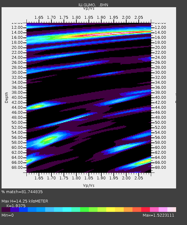
| Estimated Moho Depth: |
14.25 km |
| Estimated Crust Vp/Vs: |
1.94 |
| Assumed Crust Vp: |
4.802 km/s |
| Estimated Crust Vs: |
2.478 km/s |
| Estimated Crust Poisson's Ratio: |
0.32 |
|
| Radial Match: |
81.744835 % |
| Radial Bump: |
400 |
| Transverse Match: |
45.37299 % |
| Transverse Bump: |
400 |
| SOD ConfigId: |
6273 |
| Insert Time: |
2010-03-03 14:39:16.842 +0000 |
| GWidth: |
2.5 |
| Max Bumps: |
400 |
| Tol: |
0.001 |
|

Signal To Noise
| Channel | StoN | STA | LTA |
| IU:GUMO: :BHN:19970920T16:20:33.540002Z | 0.81682616 | 2.2301003E-6 | 2.730202E-6 |
| IU:GUMO: :BHE:19970920T16:20:33.540002Z | 0.7611898 | 1.8078711E-6 | 2.3750595E-6 |
| IU:GUMO: :BHZ:19970920T16:20:33.540002Z | 1.808623 | 3.2022053E-6 | 1.7705212E-6 |
| Arrivals |
| Ps | 2.9 SECOND |
| PpPs | 8.5 SECOND |
| PsPs/PpSs | 11 SECOND |


