You are here: Home > Network List > IU - Global Seismograph Network (GSN - IRIS/USGS) Stations List
> Station GUMO Guam, Marianas Islands > Earthquake Result Viewer
GUMO Guam, Marianas Islands - Earthquake Result Viewer
| Earthquake location: |
Fiji Islands Region |
| Earthquake latitude/longitude: |
-17.6/-179.1 |
| Earthquake time(UTC): |
1998/03/29 (088) 19:48:16 GMT |
| Earthquake Depth: |
537 km |
| Earthquake Magnitude: |
6.5 MB, 7.2 UNKNOWN, 7.1 MW |
| Earthquake Catalog/Contributor: |
WHDF/NEIC |
|
| Network: |
IU Global Seismograph Network (GSN - IRIS/USGS) |
| Station: |
GUMO Guam, Marianas Islands |
| Lat/Lon: |
13.59 N/144.87 E |
| Elevation: |
14 m |
|
| Distance: |
47.1 deg |
| Az: |
308.702 deg |
| Baz: |
130.032 deg |
| Ray Param: |
0.06766831 |
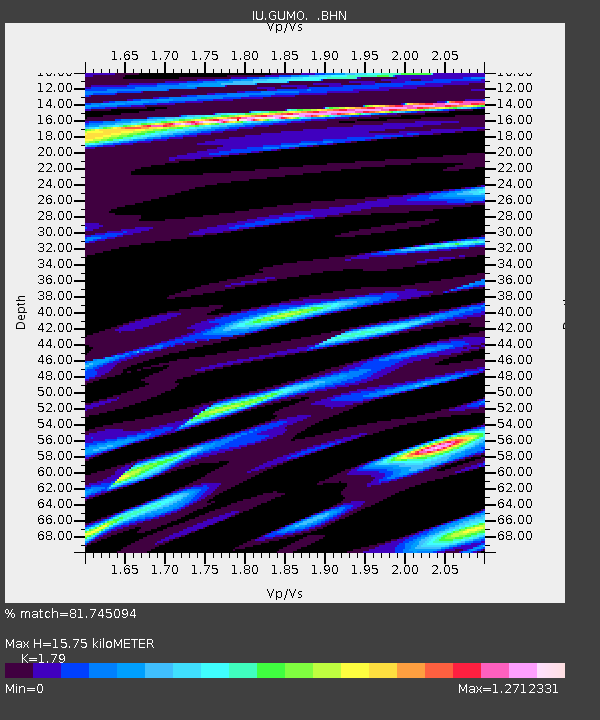
| Estimated Moho Depth: |
15.75 km |
| Estimated Crust Vp/Vs: |
1.79 |
| Assumed Crust Vp: |
4.802 km/s |
| Estimated Crust Vs: |
2.683 km/s |
| Estimated Crust Poisson's Ratio: |
0.27 |
|
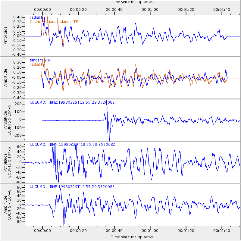
| Radial Match: |
81.745094 % |
| Radial Bump: |
400 |
| Transverse Match: |
74.24433 % |
| Transverse Bump: |
400 |
| SOD ConfigId: |
6273 |
| Insert Time: |
2010-03-03 14:39:25.223 +0000 |
| GWidth: |
2.5 |
| Max Bumps: |
400 |
| Tol: |
0.001 |
|
Signal To Noise
| Channel | StoN | STA | LTA |
| IU:GUMO: :BHN:19980329T19:55:29.352008Z | 3.2854629 | 4.637005E-6 | 1.4113704E-6 |
| IU:GUMO: :BHE:19980329T19:55:29.352008Z | 3.1307282 | 4.326887E-6 | 1.3820704E-6 |
| IU:GUMO: :BHZ:19980329T19:55:29.352008Z | 22.397152 | 2.2671644E-5 | 1.0122557E-6 |
| Arrivals |
| Ps | 2.7 SECOND |
| PpPs | 8.9 SECOND |
| PsPs/PpSs | 12 SECOND |


