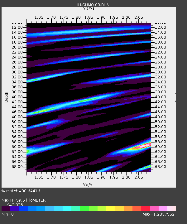
GUMO Guam, Marianas Islands - Earthquake Result Viewer
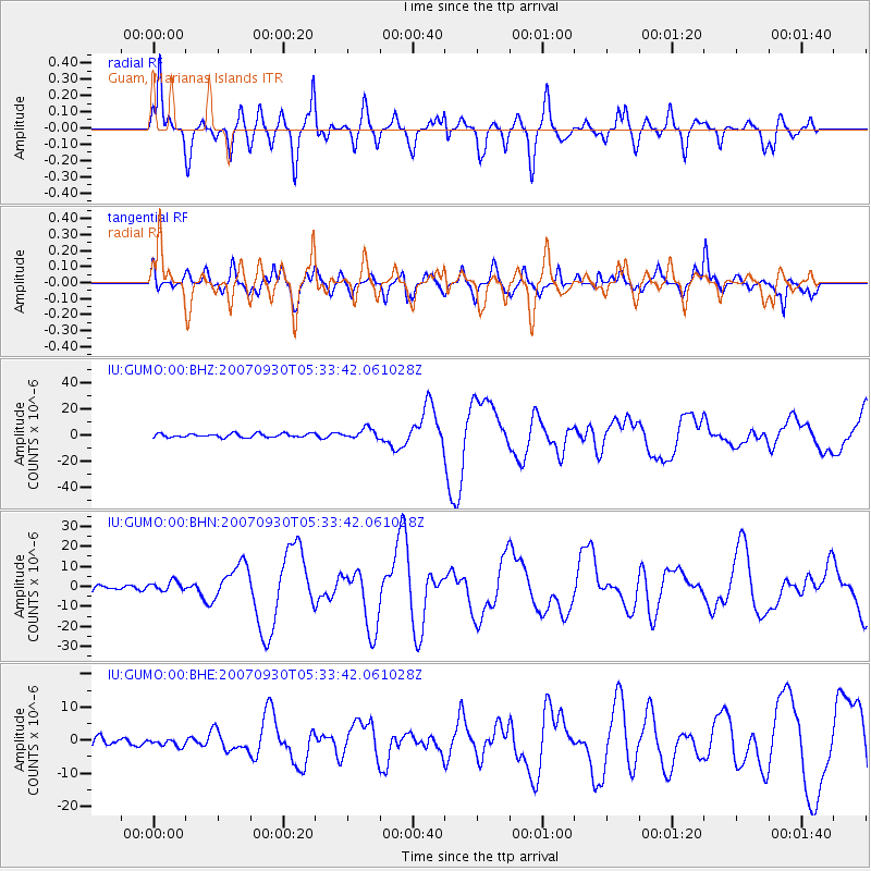
Earthquake location: Auckland Islands, N.Z. Region
Earthquake latitude/longitude: -49.3/164.1
Earthquake time(UTC): 2007/09/30 (273) 05:23:34 GMT
Earthquake Depth: 10 km
Earthquake Magnitude: 6.4 MB, 7.4 MS, 7.4 MW, 6.9 MW
Earthquake Catalog/Contributor: WHDF/NEIC
Network: IU Global Seismograph Network (GSN - IRIS/USGS)
Station: GUMO Guam, Marianas Islands
Lat/Lon: 13.59 N/144.87 E
Elevation: 14 m
Distance: 64.9 deg
Az: 339.261 deg
Baz: 166.2 deg
Ray Param: 0.058654003
Estimated Moho Depth: 59.5 km
Estimated Crust Vp/Vs: 2.08
Assumed Crust Vp: 4.802 km/s
Estimated Crust Vs: 2.314 km/s
Estimated Crust Poisson's Ratio: 0.35
Radial Match: 88.64416 %
Radial Bump: 400
Transverse Match: 80.98531 %
Transverse Bump: 400
SOD ConfigId: 2564
Insert Time: 2010-03-03 14:39:27.242 +0000
GWidth: 2.5
Max Bumps: 400
Tol: 0.001

Signal To Noise

ChannelStoNSTALTA
IU:GUMO:00:BHN:20070930T05:33:42.061028Z1.72236242.4841677E-61.4423025E-6
IU:GUMO:00:BHE:20070930T05:33:42.061028Z0.59684471.0576068E-61.7719966E-6
IU:GUMO:00:BHZ:20070930T05:33:42.061028Z2.6729683.912147E-61.4635965E-6
Arrivals
Ps14 SECOND
PpPs37 SECOND
PsPs/PpSs51 SECOND