You are here: Home > Network List > IU - Global Seismograph Network (GSN - IRIS/USGS) Stations List
> Station GUMO Guam, Marianas Islands > Earthquake Result Viewer
GUMO Guam, Marianas Islands - Earthquake Result Viewer

| Earthquake location: |
Southern Sumatra, Indonesia |
| Earthquake latitude/longitude: |
-3.2/101.5 |
| Earthquake time(UTC): |
2007/09/12 (255) 14:40:05 GMT |
| Earthquake Depth: |
35 km |
| Earthquake Magnitude: |
5.9 MB |
| Earthquake Catalog/Contributor: |
WHDF/NEIC |
|
| Network: |
IU Global Seismograph Network (GSN - IRIS/USGS) |
| Station: |
GUMO Guam, Marianas Islands |
| Lat/Lon: |
13.59 N/144.87 E |
| Elevation: |
14 m |
|
| Distance: |
46.2 deg |
| Az: |
67.867 deg |
| Baz: |
252.027 deg |
| Ray Param: |
0.07074666 |
| Estimated Moho Depth: |
17.25 km |
| Estimated Crust Vp/Vs: |
1.60 |
| Assumed Crust Vp: |
4.802 km/s |
| Estimated Crust Vs: |
2.997 km/s |
| Estimated Crust Poisson's Ratio: |
0.18 |
|
| Radial Match: |
82.78167 % |
| Radial Bump: |
315 |
| Transverse Match: |
88.89186 % |
| Transverse Bump: |
346 |
| SOD ConfigId: |
2564 |
| Insert Time: |
2010-03-03 14:39:29.074 +0000 |
| GWidth: |
2.5 |
| Max Bumps: |
400 |
| Tol: |
0.001 |
|
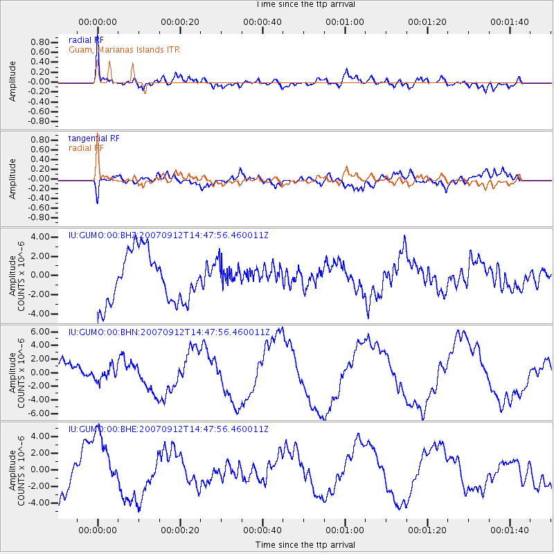
Signal To Noise
| Channel | StoN | STA | LTA |
| IU:GUMO:00:BHN:20070912T14:47:56.460011Z | 0.42349324 | 1.0575334E-6 | 2.497167E-6 |
| IU:GUMO:00:BHE:20070912T14:47:56.460011Z | 1.5144798 | 3.5424002E-6 | 2.3390212E-6 |
| IU:GUMO:00:BHZ:20070912T14:47:56.460011Z | 0.5164996 | 1.3240361E-6 | 2.5634797E-6 |
| Arrivals |
| Ps | 2.2 SECOND |
| PpPs | 9.0 SECOND |
| PsPs/PpSs | 11 SECOND |


