You are here: Home > Network List > IU - Global Seismograph Network (GSN - IRIS/USGS) Stations List
> Station GUMO Guam, Marianas Islands > Earthquake Result Viewer
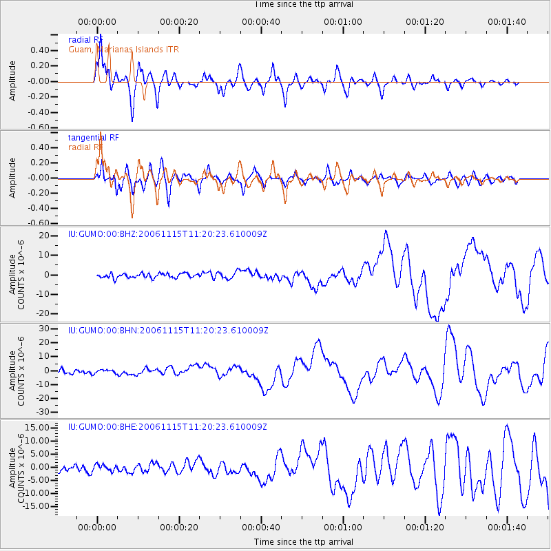
GUMO Guam, Marianas Islands - Earthquake Result Viewer

| Earthquake location: |
Kuril Islands |
| Earthquake latitude/longitude: |
46.6/153.3 |
| Earthquake time(UTC): |
2006/11/15 (319) 11:14:13 GMT |
| Earthquake Depth: |
10 km |
| Earthquake Magnitude: |
6.5 MB, 7.8 MS, 8.3 MW, 7.9 MW |
| Earthquake Catalog/Contributor: |
WHDF/NEIC |
|
| Network: |
IU Global Seismograph Network (GSN - IRIS/USGS) |
| Station: |
GUMO Guam, Marianas Islands |
| Lat/Lon: |
13.59 N/144.87 E |
| Elevation: |
14 m |
|
| Distance: |
33.7 deg |
| Az: |
194.853 deg |
| Baz: |
10.474 deg |
| Ray Param: |
0.07810954 |
| Estimated Moho Depth: |
13.25 km |
| Estimated Crust Vp/Vs: |
1.63 |
| Assumed Crust Vp: |
4.802 km/s |
| Estimated Crust Vs: |
2.946 km/s |
| Estimated Crust Poisson's Ratio: |
0.20 |
|
| Radial Match: |
93.082115 % |
| Radial Bump: |
400 |
| Transverse Match: |
81.34997 % |
| Transverse Bump: |
400 |
| SOD ConfigId: |
2564 |
| Insert Time: |
2010-03-03 14:39:33.607 +0000 |
| GWidth: |
2.5 |
| Max Bumps: |
400 |
| Tol: |
0.001 |
|
Signal To Noise
| Channel | StoN | STA | LTA |
| IU:GUMO:00:BHN:20061115T11:20:23.610009Z | 0.75311553 | 1.2491288E-6 | 1.6586151E-6 |
| IU:GUMO:00:BHE:20061115T11:20:23.610009Z | 1.110877 | 1.1661723E-6 | 1.0497763E-6 |
| IU:GUMO:00:BHZ:20061115T11:20:23.610009Z | 1.692226 | 1.93508E-6 | 1.1435114E-6 |
| Arrivals |
| Ps | 1.8 SECOND |
| PpPs | 6.9 SECOND |
| PsPs/PpSs | 8.8 SECOND |


